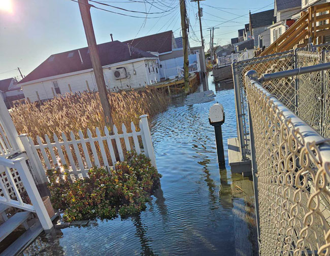
Coastal flooding due to high tide, Jamaica Bay, November 16, 2024. Credit: Joanne Furstman via MyCoast NY
Contacts:
Kathleen Fallon, NYSG Coastal Processes & Hazards Specialist, E: kmf228@cornell.edu, P: (631) 632-8730
Jessica A. Kuonen, NYSG Hudson Estuary Resilience Specialist, NYSG E: jak546@cornell.edu, P: (845) 340-3990 x323
NYSG coordinates a statewide community science program enabling the public to document and share their experiences with floods, storm damage, and coastal change through photos
Kingston, NY, May 27, 2025 - As increases in precipitation, storm frequency and intensity, and sea level rise are accelerating, New York communities are faced with the challenge of documenting and communicating increasing flood risk with limited resources.
MyCoast NY is a portal used by New Yorkers since July 2022 to collect and analyze photos of flooding, changing shorelines, and hazardous weather impacts. New York Sea Grant (NYSG) in partnership with the New York State Water Resources Institute works with partners across the state to promote its use.
MyCoast NY has captured photos of coastal and inland flooding in 26 counties across the state. In 2024, the MyCoast NY tool was integrated into the curriculum of a NYSG pilot program, the Jamaica Bay Community Flood Fellowship. Fellows and community members learned how to use MyCoast NY to record and analyze qualitative data about flooding. Additionally, NYSG integrated MyCoast NY photos into a new series of Neighborhood Flood Reports that draw on qualitative and quantitative data to create neighborhood-level portraits of flooding in New York City. In the Hudson Valley, MyCoast NY has been used to raise awareness of coastal flooding in low-lying areas along the Hudson River Estuary impacted by sea level rise.
“Photographs can show flooded areas that might be outside of mapped floodplains, or in otherwise surprising locations. It’s especially important to document these locations, as they will likely be more at risk with more extreme weather due to climate change, and often are located in lower income or disadvantaged neighborhoods. As someone who is working on flooding regionally in the Hudson Valley, MyCoast also helps me better understand impacts across a large geographic area.” — Emily Vail, Executive Director, Hudson Valley Watershed Alliance
Since inception, 867 New Yorkers have registered for MyCoast NY, and 1376 photos have been received from Flood Watch and Storm Reporter portals from 26 counties, documenting coastal and inland flooding. MyCoast NY assists the emergency management community with event monitoring and forecast improvement, and is used by local and regional organizations to understand impacts and better communicate with community members. Learn more at mycoast.org/ny.
Project Partner/Funder:
• Funding: New York State Water Resources Institute at Cornell University
More Info: New York Sea Grant
Established in 1966, the National Oceanic and Atmospheric Administration (NOAA)’s National Sea Grant College Program promotes the informed stewardship of coastal resources in 34 joint federal/state university-based programs in every U.S. coastal state (marine and Great Lakes) and Puerto Rico. The Sea Grant model has also inspired similar projects in the Pacific region, Korea and Indonesia.
Since 1971, New York Sea Grant (NYSG) has represented a statewide network of integrated research, education and extension services promoting coastal community economic vitality, environmental sustainability and citizen awareness and understanding about the State’s marine and Great Lakes resources.
NYSG historically leverages on average a 3 to 6-fold return on each invested federal dollar, annually. We benefit from this, as these resources are invested in Sea Grant staff and their work in communities right here in New York.
Through NYSG’s efforts, the combined talents of university scientists and extension specialists help develop and transfer science-based information to many coastal user groups—businesses and industries, federal, state and local government decision-makers and agency managers, educators, the media and the interested public.
New York Sea Grant, one of the largest of the state Sea Grant programs, is a cooperative program of the State University of New York (SUNY) and Cornell University. The program maintains Great Lakes offices at Cornell University, SUNY Buffalo, Rochester Institute of Technology, SUNY Oswego, the Wayne County Cooperative Extension office in Newark, and in Watertown. In the State's marine waters, NYSG has offices at Stony Brook University and with Cornell Cooperative Extension of Nassau County on Long Island, in Queens, at Brooklyn College, with Cornell Cooperative Extension in NYC, in Bronx, with Cornell Cooperative Extension of Ulster County in Kingston, and with Cornell Cooperative Extension of Westchester County in Elmsford.
For updates on Sea Grant activities: www.nyseagrant.org, follow us on social media (Facebook, Twitter/X, Instagram, Bluesky, LinkedIn, and YouTube). NYSG offers a free e-list sign up via www.nyseagrant.org/nycoastlines for its flagship publication, NY Coastlines/Currents, which it publishes 2-3 times a year.