Near-normal prediction for 2016 Hurricane Season suggests more activity in Atlantic possible than last three below-normal years; Sea Grant Produces Video on Coastal Storm Awareness
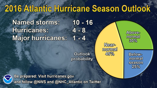
NOAA's 2016 Atlantic Hurricane Season Outlook includes a 70% likelihood of 10 to 16 named storms, of which 4-8 could become hurricanes, including 1-4 major.
AUDIO: NOAA's 2016 Atlantic Hurricane Season Outlook press conference (May 27, 2016)
Note: If you don't see the player above, it's because you're using a non-Flash device (eg, iPhone or iPad).
Contact:
Washington, DC, May 27, 2016 - The National Oceanic and Atmospheric Administration's (NOAA) Climate Prediction Center says the 2016 Atlantic hurricane season, which runs from June 1 through November 30, will most likely be near-normal, but forecast uncertainty in the climate signals that influence the formation of Atlantic storms make predicting this season particularly difficult.
NOAA predicts a 70 percent likelihood of 10 to 16 named storms (winds of 39 mph or higher), of which 4 to 8 could become hurricanes (winds of 74 mph or higher), including 1 to 4 major hurricanes (Category 3, 4 or 5; winds of 111 mph or higher). While a near-normal season is most likely with a 45 percent chance, there is also a 30 percent chance of an above-normal season and a 25 percent chance of a below-normal season. Included in today’s outlook is Hurricane Alex, a pre-season storm that formed over the far eastern Atlantic in January.
“This is a more challenging hurricane season outlook than most because it’s difficult to determine whether there will be reinforcing or competing climate influences on tropical storm development,” said Gerry Bell, Ph.D., lead seasonal hurricane forecaster with NOAA’s Climate Prediction Center. "However, a near-normal prediction for this season suggests we could see more hurricane activity than we’ve seen in the last three years, which were below normal.”
Dr. Gerry Bell discusses the 2016 Hurricane Season. (NOAA)
Bell explained there is uncertainty about whether the high activity era of Atlantic hurricanes, which began in 1995, has ended. This high-activity era has been associated with an ocean temperature pattern called the warm phase of the Atlantic Multi-Decadal Oscillation or AMO, marked by warmer Atlantic Ocean temperatures and a stronger West African monsoon. However, during the last three years weaker hurricane seasons have been accompanied by a shift toward the cool AMO phase, marked by cooler Atlantic Ocean temperatures and a weaker West African monsoon. If this shift proves to be more than short-lived, it could usher in a low-activity era for Atlantic hurricanes, and this period may already have begun. High- and low-activity eras typically last 25 to 40 years.
In addition, El Niño is dissipating and NOAA’s Climate Prediction Center is forecasting a 70 percent chance that La Niña — which favors more hurricane activity — will be present during the peak months of hurricane season, August through October. However, current model predictions show uncertainty as to how strong La Niña and its impacts will be.
Despite the challenging seasonal prediction, NOAA is poised to deliver actionable environmental intelligence during the hurricane season with more accuracy to help save lives and livelihoods and enhance the national economy as we continue building a Weather-Ready Nation.
“This is a banner year for NOAA and the National Weather Service — As our Hurricane Forecast Improvement Program turns five, we’re on target with our five-year goal to improve track and intensity forecasts by 20 percent each,” said NOAA Administrator Kathryn Sullivan, Ph.D. “Building on a successful supercomputer upgrade in January, we’re adding unprecedented new capabilities to our hurricane forecast models — investing in science and technology infusion to bring more accuracy to hurricane forecasts in 2016.”
Coming online later this season are major new investments to further improve NOAA’s ability to monitor hurricanes as they form and provide more timely and accurate warnings for their impacts. NOAA’s new National Water Model — set to launch later this summer — will provide hourly water forecasts for 700 times more locations than our current flood forecast system, greatly enhancing our ability to forecast inland flooding from tropical systems. In the fall, NOAA will launch GOES-R, a next generation weather satellite that will scan the Earth five times faster, with a resolution four times greater than ever before, to produce much sharper images of hurricanes and other severe weather.
NOAA works with a number of partners in the private and public sectors to ensure communities and businesses have the information they need to act well ahead of a land-falling hurricane.
“While seasonal forecasts may vary from year to year — some high, some low — it only takes one storm to significantly disrupt your life,” stated FEMA Deputy Administrator Joseph Nimmich. “Preparing for the worst can keep you, your family, and first responders out of harm’s way. Take steps today to be prepared: develop a family communications plan, build an emergency supply kit for your home, and make sure you and your family know your evacuation route. These small steps can help save your life when disaster strikes.”
NOAA will issue an updated outlook for the Atlantic hurricane season in early August, just prior to the peak of the season.
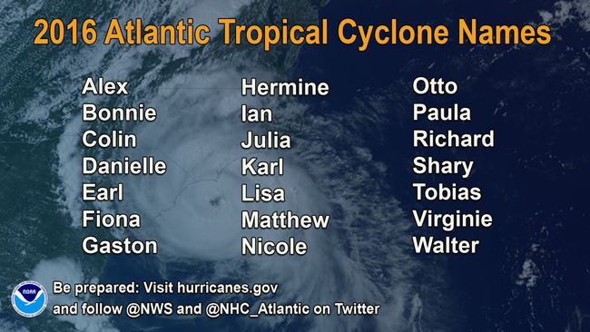
The possible names for Atlantic tropical cyclones this year
NOAA also issued its outlook for the eastern Pacific and central Pacific basins. The central Pacific hurricane outlook calls for equal 40 percent chance of a near-normal or above-normal season with 4-7 tropical cyclones likely. The eastern Pacific hurricane outlook calls for a 40 percent chance of a near-normal hurricane season, a 30 percent chance of an above-normal season and a 30 percent chance of a below-normal season. That outlook calls for a 70 percent probability of 13-20 named storms, of which 6-11 are expected to become hurricanes, including 3-6 major hurricanes.
For more of NOAA's news on weather, climate, oceans and coasts and more, click around www.noaa.gov or join the conversation on one of its various social media channels.
Sea Grant Helps NOAA Educate Coastal Communities on Hurricane Preparedness
The 4-1/2 minute trailer for NOAA Sea Grant's Coastal Storm Awareness Program's 23-minute documentary, view-able on YouTube.
Contacts:
- Barbara A. Branca, New York Sea Grant, Communications Manager, E: Barbara.Branca@stonybrook.edu, P: 631-632-6956
- Paul C. Focazio, New York Sea Grant, Web Content Manager, E: paul.focazio@stonybrook.edu, P: 631-632-6910
-
Margaret (Peg) Van Patten, Communications Director, Connecticut Sea Grant, E:
peg.vanpatten@uconn.edu, P: 860-405-9141
- Nancy Balcom, Associate Director, Connecticut Sea Grant, E: nancy.balcom@uconn.edu
- Rebecca Nagy, Communications Specialist, New Jersey Sea Grant, E: rnagy@njseagrant.org, P: 732-872-1300 x18
About a week prior to NOAA's 2016 Atlantic Hurricane Season Outlook announcement, its Sea Grant programs in New York, New Jersey and Connecticut released a short documentary and trailer to educate local emergency managers and empower coastal communities to be better prepared prior to the arrival of severe storms like 2012's Superstorm Sandy.
The video, which compliments a comprehensive final report (pdf) for NOAA's Coastal Storm Awareness Program (CSAP, www.nyseagrant.org/csap), points to resources from NOAA's National Weather Service, the Federal Emergency Management Agency, NYC Office of Emergency Management and more.
Since its release last Thursday (May 19th), the short documentary and trailer have garnered support from, among others, the Federal Emergency Management Agency, the National Oceanic and Atmospheric Administration (Sea Grant's parent federal agency), as well as a number of other key NOAA line offices, including the Office of Oceanic and Atmospheric Research and the National Weather Service. Thanks to shares from these and others during the video's first week of release, news of Sea Grant's CSAP effort has reached the Twitter feeds of nearly 1 million and, on Facebook, well over 600,000.
On Thursday, May 26th, the Sea Grant programs of New York, New Jersey and Connecticut partnered with NOAA's National Hurricane Center for a Twitter event that highlighted a number of findings from CSAP's 10 social science projects, many of which are on display in the recently-released video, featured by both Sea Grant programs in the tri-state area as well as their Washington, DC-based National Sea Grant College Program.
NYSG also offers additional resources on severe storms at www.nyseagrant.org/hurricane and www.nyseagrant.org/superstormsandy.
More Info: New York Sea Grant
New York Sea Grant (NYSG), a cooperative program of Cornell University
and the State University of New York, is one of 33 university-based
programs under the National Sea Grant College Program (NSGCP) of the
National Oceanic and Atmospheric Administration (NOAA). The NSGCP
engages this network of the nation’s top universities in conducting
scientific research, education, training and extension projects designed
to foster science-based decisions about the use and conservation of our
aquatic resources. Through its statewide network of integrated
services, NYSG has been promoting coastal vitality, environmental
sustainability, and citizen awareness about the State’s marine and Great
Lakes resources since 1971.
New York Sea Grant maintains Great Lakes offices at SUNY Buffalo, the
Wayne County Cooperative Extension office in Newark and at SUNY Oswego.
In the State's marine waters, NYSG has offices at Stony Brook University
and Stony Brook Manhattan, in the Hudson Valley through Cooperative
Extension in Kingston and at Brooklyn College.
For updates on Sea Grant activities: www.nyseagrant.org has RSS, Facebook, Twitter, and YouTube links. NYSG also offers a free e-list sign up via www.nyseagrant.org/coastlines for its flagship publication, NY Coastlines/Currents, which is published several times a year.