Policy-Makers, Including NYC Mayoral Candidates, And Scientists, Including NYSG-Funded Researcher Malcolm Bowman, Address Waterfront Challenges
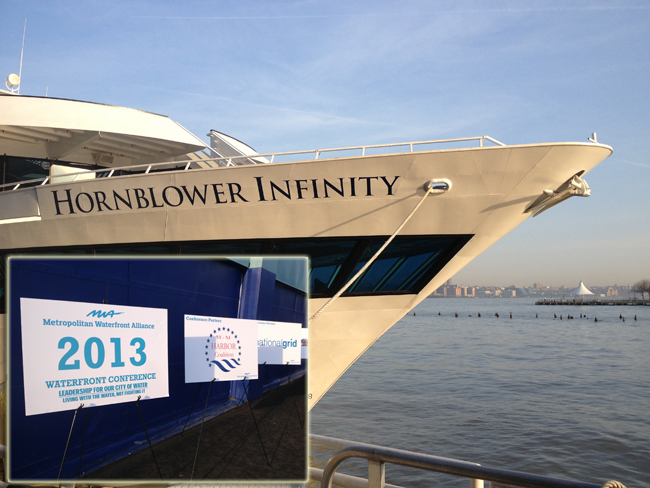
New York, NY, June 28, 2013 - More than 600 people gathered for the Metropolitan Waterfront Alliance's (MWA) 2013 Waterfront Conference aboard the Hornblower Infinity on April 9 -- including six New York City mayoral candidates and 40+ journalists from the realms of print, radio, TV and Internet -- to address pressing issues about protecting and improving hundreds of miles of metropolitan waterfront in the wake of Superstorm Sandy.
The Conference began with a Mayoral Candidates Forum. City Council Speaker Christine Quinn (pictured below, at left) was the first to describe her vision for the waterfront and take questions from moderator Christopher Ward, MWA Chairman. "We need to harness the employment potential of our waterfront," Ms. Quinn said, and called for a deputy mayor to coordinate waterfront issues. She was followed by candidates Bill de Blasio, Bill Thompson, John Liu, John Catsimatidis and Adolfo Carrion, Jr.
Pushing for a deputy mayor for infrastructure to oversee waterfront development, Thompson offered a specific financing plan for ferry subsidies when challenged by Mr. Ward. First, he said, he would tie ferries into the larger mass transit system and then he would pay for them by bringing back the commuter tax for mass transit and establishing a weight-based registration fee for vehicles. This, Thompson said, would generate $1.7 billion to $2 billion.
 Photo: MWA
John Liu said he likes the idea of inclusionary zoning for waterfront properties, and called for "stronger oversight and regulation" on the waterways. He said he would move government dollars from highway funding to mass transit to pay for ferry subsidies.
Mr. de Blasio compared the NYC waterfront to Seattle's, where he said he was struck by "the holistic system embedded in people's lives in a good way."
Mr. Catsimatidis, who owns shoreline properties, spoke of the potential for new jobs and business along the waterfront.
Mr. Carrion noted an unexploited opportunity for eco-tourism. He also said he would create a Community Board-type governance structure for waterfront communities.
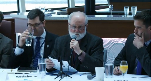
Six panels of experts discussing of-the-moment waterfront topics rounded out the rest of the day, the later four while the boat cruised around New York Harbor. Among the speakers were, Stony Brook University (SBU) School of Marine and Atmospheric Sciences (SoMAS) oceanography professor and storm surge expert
Malcolm Bowman (pictured above at the Conference) and Stevens Institute of Technology research scientist
Philip Orton, both of whom are currently being funded by New York Sea Grant (NYSG) on separate studies.
Orton is an investigator on a project that began this past March to simulate the effects of climate on Long Island Sound's physical environment and living marine resources. "Over the last few decades, this ecosystem has undergone profound changes," he says. "Sparse long-term water temperature observations within the Sound have recorded a warming trend, consistent with Northeast shelf waters warming. And while large-scale temperature increase and changes in circulation have been hinted as the most important factors associated with fisheries-related shifts, an understanding of how such processes affect the Sound's stocks is limited due to the lack of available physical environment data."
Along with researchers from CT Department of Energy and Environmental
Protection's Marine Fisheries Division, NOAA/National Marine Fisheries
Service's Northeast
Fisheries Science Center and others at Stevens Institute of Technology,
Orton is analyzing historical data to help project and manage the Sound
going forward.
For the last decade, NYSG has provided principal funding to SBU' SoMAS Storm Surge Research Group, led by Bowman, to work on storm surge science, coastal defense systems and policy issues related to regional protection of New York City and Long Island. In their most recently NYSG-funded project, which began in February 2012 and runs through early 2014, the Group is working towards creating a more accurate ensemble-based and wave setup-enabled storm surge model prediction system that could easily be adopted by the National Oceanic and Atmospheric Administration (NOAA) National Weather Service as well as regional emergency managers for regular and accurate predictions over the Northeast seaboard with a focus on Metropolitan New York and Long Island.
When Sandy hit late last October, Bowman, along with investigator Brian Colle and others from the Storm Surge Research Group, kept close tabs on the superstorm before, during and after landfall. The Group provided their results via E-mail, the Group’s Web site, and NYSG’s Web site. And, during the height of the storm, NYSG’s Twitter and Facebook feeds were the primary avenues for providing information as many (including the University) lost power and network connections. In some cases, the group was able to correct some of the storm-related inaccuracies reported about coastal flooding in lower Manhattan.
A heightened level of activity, planning and intense discussions have marked these early months after Superstorm Sandy impacted the New York area. So, the objective during a session at the MWA's Conference on "Protecting the New York-New Jersey Harbor" was, as read by moderator Seth Pinsky from NYC Economic Development Corporation: "One of the worst storms in our region's history deserves this intense attention. Collectively we want to know what to do, how to prevent catastrophes from future storms, and we seek a clear path forward." This talk can be streamed in its entirety below.
Protecting NY-NJ Harbor by MetroWaterfront
During the discussion, Bowman, Orton and other panelists addressed some
of the questions and concerns related to severe storms like Superstorm
Sandy, like: What happened during Superstorm Sandy and what does it mean
for us moving forward? What does the future hold for NYC given climate
change? What do we do as a city given what we've seen with Sandy? As the
panelists discuss during the talk, the answers are simple, but the
solutions are quite complex: There's a need for some possible changes in
legislation as well as continued aid and outreach efforts.
Depending on who you talk with, you'll get a different answer on how the
New York metro area should address the issues of climate change, severe
storms and their storm surges. "With gates, wetlands, dunes, and even
oyster reefs as options," said Pinsky, "how do we protect our nation's
cultural and financial capital and the more than 20 million people who
call it home in a financially and environmentally sustainable and sound
fashion?"
"There are a number of ways to look at recovering from storm surge or
these types of events," added panelist Andrew H. Cairns, Regional Market
Sector Manager for Ports & Marine, AECOM and Board Member, Coast,
Oceans, Ports and Rivers Institute within the American Society of Civil
Engineers. "There's resisting - preventing this from ever happening by
building permanent sea walls. Then, there's reinforcing - some softer
things like dune reconstruction, wetland restoration and beach
nourishment. Also, looking at things like plugging the tunnels as well
as some water stops or flood walls and stop blocks to prevent the water
from getting into critical infrastructure. You can restrict things - you
can change building codes so that we don't make mistakes moving
forward. Or, you can retreat, and that's really a political decision.
And the will of the people."
About 35 minutes into the discussion, Bowman confirmed one of the key points that many of his fellow panelists brought up: "As we've heard, this is not just a New York City problem. It's a New Jersey problem, a Long Island problem ... I hear a clamor of voices all around me about what to do next. I see a clash of cultures ... and there's a lot of talking past each other, all with good intention. I believe this confusion will continue until our political leaders agree that this Sandy-induced catastrophe must never be allowed to happen again. And if our political leaders will make that statement, then I think that will clarify a lot of what the solutions should be, how much they might cost, what's affordable/what's not, what's local/what's regional."
Bowman says we need to hash out a regional plan that coordinates the efforts the city and the greater New York metro area will take part in because "the individual agencies do not have the resources to address this issue in the bigger picture to ensure this situation never happens again." Some of the other points Bowman touched upon during the session, which are paraphrased here and can be viewed in their entirety in the video stream above, include:
- If New York is going to keep it's competitive edge in harbors in ports, we need to be proactive and be solution-based. Ideas like shallowing of channels are not probable, as New York Harbor appears to be deepening.
- Evacuation? "We tried that with Sandy and it didn't work."
- We'll end up like the Netherlands 75 years from now if we're not aggressive with our responses to severe storms and surges.
- We can't climate-proof everything. Will we know what and when the next storm will be?
- When designing for sea level rise, should Sandy be the model or is it an anomaly?
- Sea level rise is expected to accelerate with the Greenland ice melt - possibly 3 to 6 feet by the end of the century. We're not in a period of high acceleration yet, but we need to prepare.
- Let's get the most technologically-feasible, environmentally-sustainable and financially acceptable safety measure in place, being aware that planning is not only crucial but also time-consuming. Bowman encourages to act now with scientific studies so that we can prepare and implement over time. Bowman says that we should agree that climate change is happening and plan accordingly.
- While rising sea levels isn't such a major concern right now, some buyout options to retreat low-lying areas are likely by NY's Governor in the next few decades as a preventive measure. Bowman spent time in Breezy Point, Queens, a place wrought with emotions following Sandy's aftermath. But, he says, you cannot have it both ways - it's either a scenic view or security with sea walls.
During the hour-long talk, Orton made some points as well, which are summarized here:
- There is a lot of high ground in and around New York City - we need to make evacuation of lower-lying areas more appealing.
- Though Orton agrees that sea walls storm barriers should be studied more from a holistic standpoint, he says that you can create a fragile system instead of a protective system, as you'll need to keep raising those walls over time. It's a mater of property protection versus a human protection measure. "There's not an easy or quick solution to this problem," he says.
Later in the day, Bowman was a panelist on another session, "Build a
Good Study - Build a Better Coast." The discussion, which can be
streamed in its entirety below, zeroed in on government studies dictating the course of resiliency.
Build a Good Study, Build a Better Coast by MetroWaterfront
A few of the questions that Bowman and his fellow panelists were asked to address during this session included:
- How can we ensure equal weight is given to protection measures that are decentralized and provide ecological benefits such as changing building codes, re-nourishing beaches, restoring wetlands, greening the waterfront, capturing and releasing water, and sealing buildings?
- How can we make sure studies weigh the extra costs of making resilient our vital infrastructure versus the costs required to replace that infrastructure in the event of storm surges, extreme weather, and/or other coastal hazards?
This panel explored these factors and what decision makers must include in any study design, the time and places where study designs will be made final, and the role of the academic and civic communities in influencing these processes.
During the session, Garret Graves, Chairman of the Coastal Protection and Restoration
Authority of Louisiana, proved to be one of the most dynamic speakers of
the day, saying at one point, "It's important to act now! The attention
you're getting now is going to wane. Identify the no-regrets/no-brainer
projects now and push for funding. Don't wait two years!"
Graves had plenty of other advice. "You have to be open to
reconfiguration," he said. "Don't plan for another Sandy. Plan for the
next storm. I guarantee you there are other vulnerabilities here. You
need to be aggressive, and you need to act now."
Other speakers in sessions held during this annual conference included:
- Alex Brash, Northeast Regional Director, National Parks Conservation Association
- Jim Tripp, Senior Counsel, Environmental Defense Fund
- Jamie Rubin, New York State Director, Hurricane Sandy Recovery Task Force (HUD)
- Will Shafroth, Acting Commissioner, National Parks of New York Harbor.
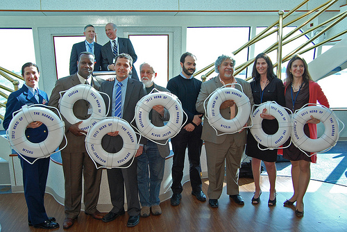 Photo: MWA
The honoring of MWA's "Heroes of the Harbor" took place during the conference cocktail hour. 2013 Heroes, from left to right, are:
- Lt. Cmdr. Anne Morrissey, Chief of the Waterways Management Division, Coast Guard Sector New York; accepting on behalf of the Marine Transportation System Recovery Unit
- Dr. Reginald Blake, CUNY Graduate Center; accepting on behalf of the NYC Panel on Climate Change
- Capt. Jonathan Boulware, Waterfront Director, South Street Seaport Museum
- Dr. Klaus Jacob, Columbia University
- Juan Camilo Osorio and Eddie Bautista, Policy Analyst and Executive Director, NYC Environmental Justice Alliance
- Angela Licata, Deputy Commissioner for Sustainability, NYC Department of Environmental Protection
- Susannah Drake, Founder, dlandstudio architecture and landscape architecture
New York Sea Grant is one of the Metropolitan Waterfront Alliances (MWA) over 650 partners with ties to our regional waterways. "Together we are working to transform the waters of New York and New Jersey Harbor into clean and accessible places to learn, work and play, with inviting parks, dependable jobs and reliable, eco-friendly transportation for all," says MWA President and CEO
Roland Lewis. For more on MWA, its mission, initiatives and events, see
www.waterfrontalliance.org.
Event Photo Series: Post-Sandy Tour and Update
 This and all photos below taken during the MWA Conference on April 9, 2013 by Paul C. Focazio, NYSG
New York Sea Grant's
Nordica Holochuck, Hudson River Specialist, and
Paul C. Focazio, Web Content Manager, attended this year's Metropolitan Waterfront Alliance (MWA) Waterfront Conference. After listening to the NYC Mayoral discussion and participating in the first two panel sessions, Holochuck, Focazio and the hundreds of other attendees set sail on the Hornblower Infinity (pictured above) from Pier 40 in Hudson River Park and, while taking in discussions from the final four panels of experts, cruised around
New York Harbor.
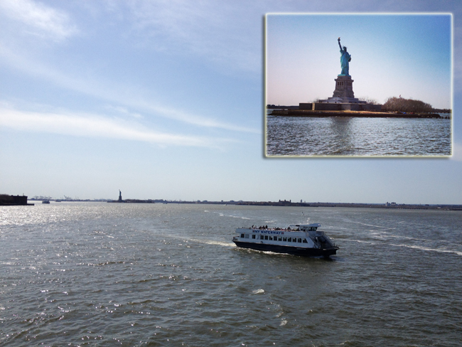
In the wake of Sandy late last October, Liberty Island (home to the Statue of Liberty, pictured below in insert picture) and Ellis Island were both closed indefinitely while the National Park Service assessed post-storm damage. Although the statue itself was not damaged by the storm, Liberty Island suffered significant damage to its infrastructure. Bricks were ripped up from pavements and Liberty Island’s dock, where tourists arrive by ferry may need to be rebuilt completely.
The Statue of Liberty, which celebrated its 125th year in 2012, had just completed an extensive $30-million renovation project that closed her crown to visitors for a year. Her long-awaited re-opening lasted for just six hours before Sandy crashed into New York Harbor. Damage to her flood-water soaked mechanical systems had laid the iconic structure dark for approximately two weeks. Lady Liberty was finally illuminated on Friday, November 9, 2012 for the first time since the massive storm.
Though Ellis Island remained in the dark for several weeks after the storm, according to museum officials, there was little or no damage to the curatorial and archival collections stored in the Immigration Building.
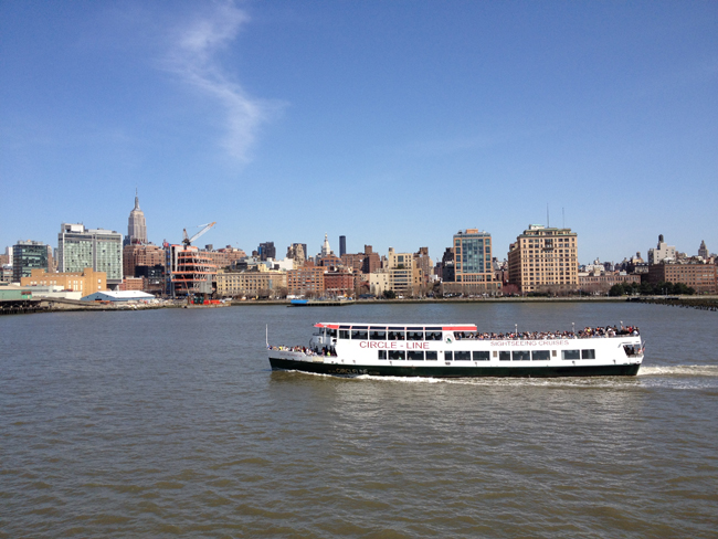
Due to the closures of both Liberty and Ellis Islands, a number of companies providing ferry transportation to and from the islands - including Hornblower Cruises, a sponsor of the Metropolitan Waterfront Alliance's 2013 Waterfront Conference, and Circle Line Sightseeing tours (whose boats are pictured above and below) - were forced to curtail operation.
Business is scheduled to set sail again, though, as the National Park Service will reopen the Statue of Liberty on July 4, 2013, after months of repair to the island's damaged docks, energy infrastructure and security system caused by Superstorm Sandy. Ellis Island, however, will remain closed until further notice. For more information, see the National Park Service's Statue of Liberty Web site:
www.nps.gov/stli.
Stony Brook University (SBU) School of Marine and Atmospheric Sciences
(SoMAS) oceanography professor and storm surge expert Dr. Malcolm Bowman
leads the University's Storm Surge Research Group, which has received
principal funding from New York Sea Grant for the last decade. Bowman
has studied Sandy's evolution since it tracked up along the East Coast,
impacting a number of flood-prone areas along the New Jersey, metro New
York and Long Island coastlines.
Brian Colle, a SBU SoMAS
researcher and Storm Surge Research Group investigator, says, during the
storm, there was, for example, "confirmed flooding at the Ground Zero
site, Hoboken train station (Path trains), and Midtown and Battery
Tunnels."
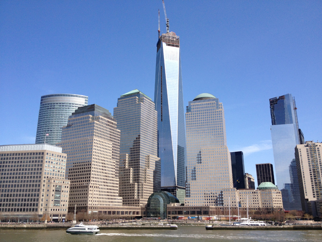
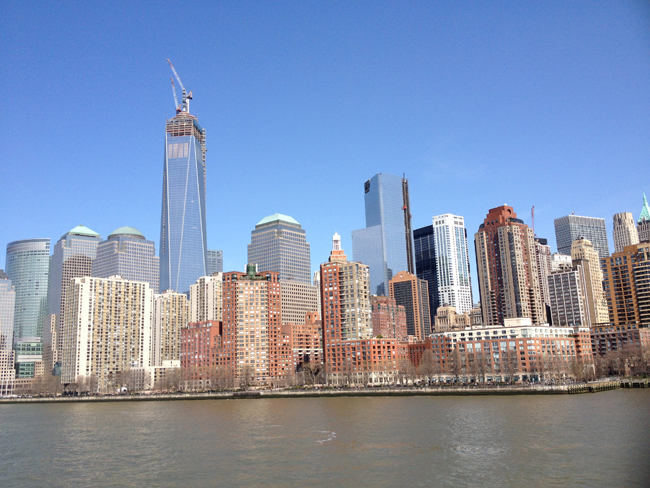
At a lecture at SBU Southampton in mid-November 2012,
just a few weeks after Sandy, Bowman explained what the storm surge was
like at the Battery, the southernmost portion of Manhattan (pictured
above and in the three pictures below). He first provided the National
Oceanic and Atmospheric Administration's definition of a storm surge -
the rise of water driven toward shore by storm winds, over and above
predicted tide levels. Storm-surge flooding varies widely, depending on
the height of terrain along local coastlines.
"As the winds
start blowing water around, they create waves. And the stronger the
winds, the bigger the waves and faster they move. But also, the winds
push water around. As that water pushes up against the coast, it builds
up. And that's what we call the storm surge. Part of this storm surge is
the waves, too, because if they break on the beach they can create
another surge on top of the wind surge."
"The New York
Metropolitan region is vulnerable to coastal flooding and large-scale
damage to city infrastructure from hurricanes, nor'easters, and other
severe storms like Sandy," Bowman added, reminding attendees that much
of this region lies less than three meters above mean sea level. Within
this area - which, in total, includes an area of about 260 square
kilometers -lies critical infrastructure such as hospitals, airports,
railroad and subway station entrances, highways, water treatment
outfalls and combined sewer outfalls at or near sea level.
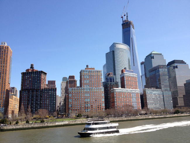
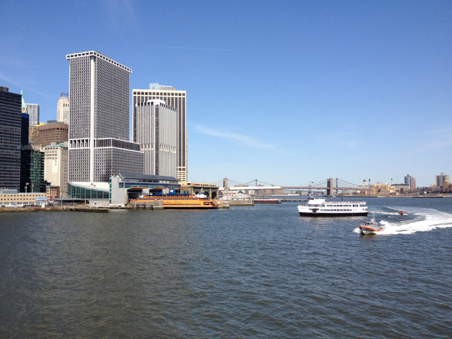
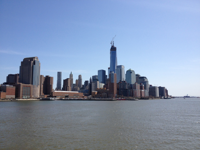
After traveling around The Battery at the southernmost tip of Manhattan, the Hornblower Infinity made its way up the East River (pictured above, towards the right), which is connected between Manhattan (at left) and Brooklyn (at right) by (in order), the Brooklyn, Manhattan, and Williamsburg Bridges.
More Info:
New York Sea Grant (NYSG), a cooperative program of Cornell University
and the State University of New York, is one of 33 university-based
programs under the National Sea Grant College Program (NSGCP) of the
National Oceanic and Atmospheric Administration (NOAA). The NSGCP
engages this network of the nation’s top universities in conducting
scientific research, education, training and extension projects designed
to foster science-based decisions about the use and conservation of our
aquatic resources. Through its statewide network of integrated
services, NYSG has been promoting coastal vitality, environmental
sustainability, and citizen awareness about the State’s marine and Great
Lakes resources since 1971.
For updates on Sea Grant activities:
www.nyseagrant.org has RSS,
Facebook,
Twitter, and
YouTube links. NYSG also offers a free e-list sign up via
www.nyseagrant.org/coastlines for NY Coastlines, its flagship publication, and Currents, its e-newsletter supplement, each distributed several times a year.