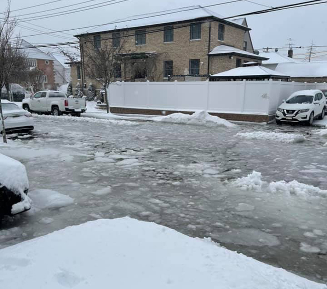
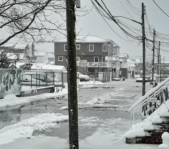
Flooding from high tide (9:53 am) and snow during Nor’easter on December 17, 2020 - 98th St, btw 161st/162nd Avenues, Howard Beach, Queens, NY at 11:05 am. Credit: Maureen Lowery via NYC Community Flood Watch Project on Facebook.
— By Chris Gonzales, Freelance Science Writer, New York Sea Grant
Flood Watch Project Provides Communities With Tools to Increase Resiliency
Queens and Brooklyn, NY, December 20, 2020 - New York City’s coastal communities are facing more frequent weather disruptions such as floods, which, according to a new research brief on “Flood Watch Social Impacts,” is a hazard that will continue to increase in its severity due to sea level rise. Chronic stressors are causing flooding on sunny days, when unusually large tides bring water into low-lying waterfront neighborhoods.
So-called “sunny day” floods, also called “nuisance” or “high-tide flooding,” can impact these coastal areas, as detailed in NOAA’s most recent “State of High Tide Flooding and Annual Outlook.”
Such neighborhood flooding can block people’s access to subway stations, delay the mail, and disrupt city services. It can even damage property or keep people from getting to work or routine medical appointments.
For more, see "NYSG Provides Fast Draw Video on High Tide Flooding"(July 2020)
To learn more about this type of flooding, the Community Flood Watch Project (Flood Watch) was created. It is coordinated by New York Sea Grant (NYSG) and the Science and Resilience Institute at Jamaica Bay (SRI@JB) in partnership with New York City Emergency Management and the New York City Mayor’s Office of Resiliency.
“Models and forecasts only tell half the story of flooding in coastal communities,” said Helen Cheng, former NYSG coastal resilience specialist. “There is value in on-the-ground information and community-collected data. These data are coming from residents who live in these areas and are experiencing these events, 24 hours a day, 7 days a week. And in turn, these data can not only further validate forecasts but also provide information on how flooding will impact community well-being and livelihood.”
“The Community Flood Watch Project is a collaboration between resident volunteers, scientists and government agencies, all with a shared goal to increase resilience to flooding in the face of rising sea levels,” said Katie Graziano, NYSG’s coastal extension specialist.
Trained community members collect photographs as well as data about tidal flood events. These data record the date, time, depth, duration, and source of flooding. Project coordinators and community members also collect first-hand accounts from residents who had witnessed flooding.
“The Flood Watch program started in 2018 in the Jamaica Bay area,” said Dana Kochnower of the New York City Mayor’s Office of Resiliency (MOR). “Since then, it has gathered 377 reports from individuals about neighborhood, sunny-day flooding.”
“Community flood reports allow researchers to improve flood forecasts and alerts, empower residents to communicate flood impacts on their daily lives, and give decision-makers a better understanding of current issues and potential interventions,” said Graziano.
Such reports about floods in all types of weather, including on mild days, are valuable because they can help researchers improve forecasting models so that flood warnings can be more accurate and informative as sea level rises.
Intrigued by the pictures of flooding impacts, project partners wanted to learn more. Flood Watch partners decided to conduct a pilot social science project to learn more about how these flooding episodes impact people’s lives. The Flood Watch partners teamed with investigators from the U.S. Department of Agriculture's Forest Service (USFS) NYC Urban Field Station to conduct a pilot study related to the experiences of those living with flooding in the Jamaica Bay watershed. In this trial, Flood Watch interviewed nine residents, each for up to an hour-and-a-half, to learn about their experiences with this flooding.
As mentioned earlier, the project team recently put together a research brief, “Flood Watch Social Impacts,” based on this experimental work. The brief was authored by USFS’s Lindsay Campbell and Erika Svendsen; ORR’s Dana Kochnower and Phoebe Wapnitsky; SRI@JB/NYSG’s Helen Cheng (former); and NYSG’s Kathy Bunting-Howarth.
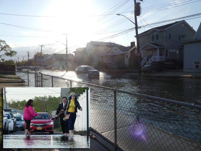
Flooding doesn't only happen in bad weather. The phenomenon of “sunny day flooding” is just as it sounds–the weather may have been sunny, dry and calm for a week and yet the rising tide works its way up through storm drains, flooding the streets with seawater. The parking lot of (and nearby streets to) the Howard Beach Motor Boat Club turned into a reflecting pool with several inches of seawater on the evening of May 15th, 2019, coincidental with a Flood Forum designed to provide resources for community members to prepare for the risks and challenges of coastal homeownership in the face of rising seas and a changing climate. The impact of the flooding was tangible as (in inset) attendees removed shoes and socks to wade through the parking lot to the entrance. Credit: Ryan Strother / NYSG.
“Catastrophic flooding associated with large storms like hurricanes gain great attention, but people’s lives are often disrupted by the smaller, more frequent street-level floods that accompany high tides and high-intensity rain events,” said Kathy Bunting-Howarth, NYSG’s associate director. “This pilot study sought to test a protocol to learn more about people’s lived experience with flooding where it occurs, how it impacts them, and how they adapt their behaviors to mitigate risk.”
The team, having gathered first-hand accounts from residents through interviews, conducted an analysis of the data, which revealed new detail about the social, economic, and psychological impacts of floods in normal weather. From these interviews, researchers also assembled a roster of “adaptations” or responses residents made in order to cope with the flooding. These include decisions such as changing travel routes or times, moving their car, moving items out of the basement, or even buying a high-clearance vehicle such as an SUV. Some residents even mentioned moving out of the neighborhood.
According to researchers who tabulated responses, the most common effect of flooding was people’s emotional distress or frustration. This was followed by missing or being late for work, school, or an appointment. Property damage was noted in third.
During an interview, one coastal resident said:
“We were supposed to have Christmas here one year at the old house. And all of a sudden, Christmas Eve, we get a high tide. It's a freak high tide. … I had just finished replacing the rug for the kids to come over to play downstairs, and the tide came in and hit the rug…We had to cancel that day…So, you know, it bums you out. My wife was bummed out. She had started cooking three days before [Christmas].”
For more, see "CUNY TV's Simply Science Spotlights Jamaica Bay Flood Watch" (November 2019)
In conclusion, the city’s low-lying neighborhoods are more often being affected by flooding even on sunny days, and these events typically happen without media attention. Scientists know these events are happening more frequently due to sea level rise. This research shows some of the specific quality-of-life effects that are ongoing today with periodic flooding during normal weather.
Flood Watch is currently active in Hamilton Beach, Howard Beach, and in the eastern side of the Rockaways, in Queens, New York. It is now expanding into Coney Island, the Bronx, and any neighborhood where residents are willing to volunteer their time to send in flood reports.
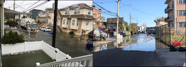
First street in Hamilton Beach, Queens, NY 11414 (At left); Beach 84th Street in Rockaway, Queens, NY 1169 (At right). Credit: Community Flood Watch Project NYSG and SRIJB.
For more, see "Community Flood Watch Project Engages Residents in Reporting and Mitigation" (October 2020)
Why High-Tide Flooding Happens
High-tide flooding is happening with increasing frequency due to climate change. A higher relative sea level, land subsidence (sinking), and the loss of natural coastal barriers are each contributing factors. In 1950, it would take a considerable amount of water to cause a high tide flood. Now, it no longer takes a strong storm or hurricane to cause flooding.
As illustrated in the infographic below from the National Oceanic and Atmospheric Administration’s National Ocean Service, high tide flooding, especially on the US East and Gulf Coasts, is becoming more frequent, and can be caused by a mere high tide.
In contrast to highly visible extreme storm events of a short duration, sunny day flooding occurs gradually over time, creating persistent, but nonetheless harmful effects.
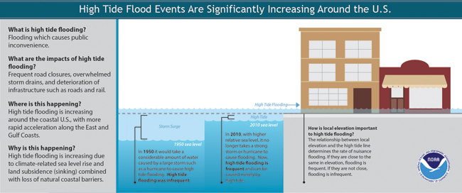
High tide flood events are significant increasing around the U.S. Credit: National Ocean Service, National Oceanic and Atmospheric Administration.
In Photos: Flooding from high tide (9:53 am) plus Nor’easter snow on December 17, 2020
(submitted via NYC Community Flood Watch Project on Facebook)
Davenport, Ct, Hamilton Beach, Queens, NY (11 am). Credit: Laura Nizzo Marcelin.
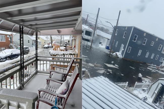
(At left) First Street, Hamilton Beach, Queens, NY at 11:57 am; (At right) Hawtree Creek Rd, South Ozone Park, Queens, NY at 11:17 am. Credit: respectively, Cheryl Reichling-Volkens, Virginia Poynter.
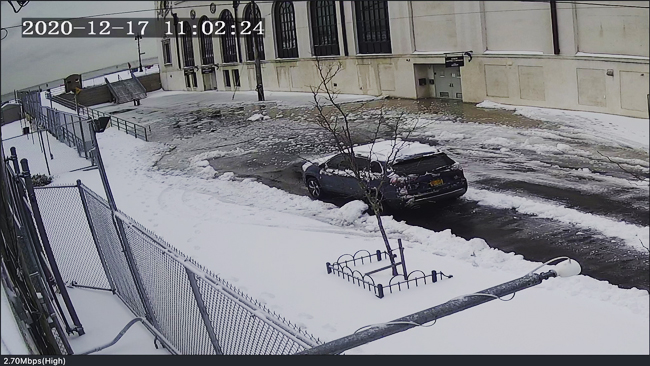
Coney Island, Brooklyn, NY, on West 21st near the boardwalk (near the Ford Amphitheater), storm drains backed up with the combination of slush and high tide at 11:02 am. Credit: Community Board 13.
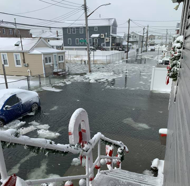
E 6th Road in Broad Channel, Queens, NY. Credit: Michelle Kenny.
More Info: New York Sea Grant and SRIatJB
The Science and Resilience Institute @ Jamaica Bay
(SRIJB) is a research center focused on enhancing environmental,
social, and economic resilience in communities of Jamaica Bay funded by
the Rockefeller Foundation and the City of New York.
New York Sea Grant (NYSG), a cooperative program of Cornell University
and the State University of New York (SUNY), is one of 34 university-based
programs under the National Oceanic and Atmospheric Administration’s
National Sea Grant College Program.
Since 1971, NYSG has represented a statewide network of integrated
research, education and extension services promoting coastal community
economic vitality, environmental sustainability and citizen awareness
and understanding about the State’s marine and Great Lakes resources.
Through NYSG’s efforts, the combined talents of university scientists
and extension specialists help develop and transfer science-based
information to many coastal user groups—businesses and industries,
federal, state and local government decision-makers and agency managers,
educators, the media and the interested public.
The program maintains Great Lakes offices at Cornell University, University at Buffalo, SUNY Oswego and the Wayne County Cooperative Extension office
in Newark. In the State's marine waters, NYSG has offices at Stony Brook
University in Long Island, Brooklyn College and Cornell Cooperative
Extension in NYC and Kingston in the Hudson Valley.
For updates on Sea Grant activities: www.nyseagrant.org has RSS, Facebook, Twitter, Instagram, and YouTube links. NYSG offers a free e-list sign up via www.nyseagrant.org/nycoastlines for its flagship publication, NY Coastlines/Currents, which is published quarterly. Our program also produces an occasional e-newsletter,"NOAA Sea Grant's Social Media Review," via its blog, www.nyseagrant.org/blog.