

********************** NEW in 2011 **********************
Interpretive Panels: ELODWA and Skinner Creek
A series of 10 interpretive panels were designed and installed in the Sandy Creeks watershed including the Eastern Lake Ontario Dunes & Wetlands Area. Please select the links below to view the panels and use the navigational map located at the bottom right of each panel to see where you can view each panel in the ecosystem. Project partners include New York Sea Grant, Great Lakes Seaway Trail, New York State Tug Hill Commission and the New York State Department of Environmental Conservation with funds from New York State Department of State.
Bird Sanctuary Panel - El Dorado Nature Preserve
Backdune Wetlands Panel - Black Pond WMA
Backdune Wetlands Panel - Lakeview WMA
Bird Sanctuary Panel - Sandy Pond Beach
Interpretive Panel: Tony Kotz/TODC partnership vision
New York State Parks is hosting an interpretive panel at Sandy Island Beach State Park. This new panel was developed in memory of the Eastern Lake Ontario Dune Coalition's former Chairperson, Tony Kotz. It also highlights the key to the coalition's success along ELODWA, PARTNERSHIPS! Please select the link below to view the panel.
Eastern Lake Ontario Dunes & Wetlands Area Fact sheets
A series of fact sheets was deveoloped as a component of the Eastern Lake Ontario Dunes & Wetlands Area (ELODWA) Traveling Trunk. Both formal and informal educators will be able to bring ELODWA education to their lessons without traveling to the unique and fragile coastal freshwater dune ecosystem. Please slect the links below to view facts sheets. The New York State Department of State, Division of Coastal Resources provided project funding. Other project partners include the New York State Department of Environmental Conservation, Oswego County BOCES, Oswego County Soil and Water Conservation District, The Nature Conservancy, and Town of Sandy Creek.
********************************************************
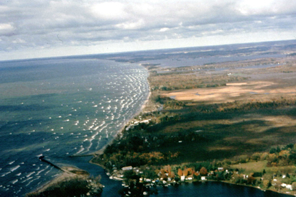
| The sand dunes along the eastern shore of Lake Ontario are an integral part of a coastal barrier environment that consists of beaches, sand dunes, embayments and wetlands. This barrier system, which extends for roughly 17 miles, contains the largest and most extensive freshwater sand dune formations in New York State. |

Click on the tabs above to discover more about this fascinating coastal environment, including it's flora and fauna, the trails and boat routes available, and how you can help protect this area. If you are interested in educational activities, check out the Dune Fun pages and the Activities for Learning More pages. For more technical information about the dunes and wetlands, visit the reference pages and the publications pages. Enjoy your visit!!
NEW!!!
2010 Monitoring Recreational Use in the Eastern Lake Ontario Dune & Wetland Area--(PDF report)
For
additional information on the eastern Lake Ontario Dunes and Wetlands
contact:
Mary Penney
Coastal Community Development Specialist
New York Sea Grant Extension Program
315.312.3042
mp357@cornell.edu