Recreation

The sand dunes along the eastern shore of Lake Ontario are an integral part of a coastal barrier environment that consists of beaches, sand dunes, embayments and wetlands.

This barrier system, which extends for roughly 17 miles, contains the largest and most extensive freshwater sand dune formations in New York State.

Discover more about this fascinating coastal environment, including it's flora and fauna, the trails and boat routes available, and how you can help protect this area.

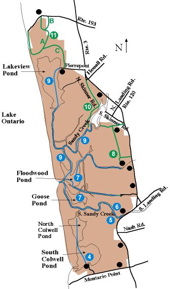
Lake Ontario Dune Trail

Map marker: 11, Green
Trail length: Main trail (11A) is a 2.0-mile loop; short trail (11B) is a 0.7-mile loop; and trail to Lakeview Marsh Wildlife Management Area (11C) is 0.6 miles (one way) Difficulty: Easy
Type of use: Hiking
Trail description: The trail starts at Southwick Beach, passes through Lakeview Marsh WMA, and loops back to Southwick Beach. Along the way, you'll see many different habitats: woodlands, abandoned apple orchards, meadows, red cedar-maple forests, marshes, and sand dunes. A dune walkover on the trail enables you to cross the dunes without harming them. After crossing the walkover, take a right on the beach and follow it back to Southwick Beach State Park. This trail can be muddy so wear your boots!

If you are interested in hiking a shorter loop, take the first left turn you come to (trail 11B). This trail goes through abandoned apple orchards.

The second left turn you come to (trail 11C) will take you to the Lakeview Marsh Wildlife Management Area boat launch on Pierrepont Road. This trail passes through woodlands and meadows.

How to get there: Take Route 3 to the Southwick Beach State Park entrance road. The trailhead is opposite the park's entrance booth.
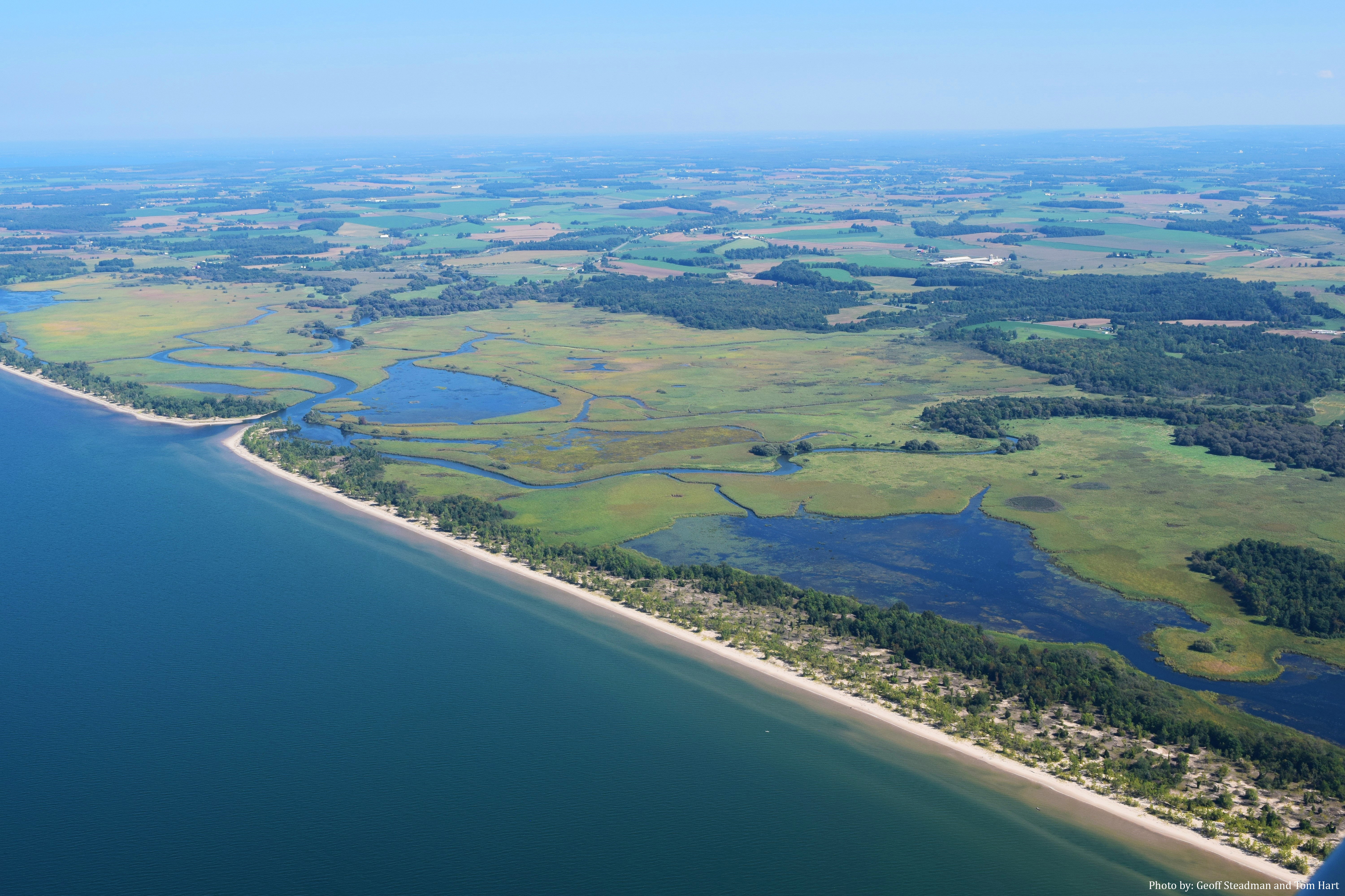
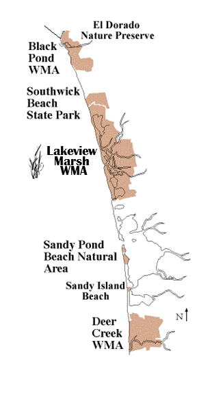
North Skinner Road and Trail

Map marker: 10, Green
Trail length: North Skinner Road is 0.6 miles (one way); the trail is 0.4 miles (one way)
Difficulty: Easy
Type of use: Hiking and mountain biking
Trail description: North Skinner Road is an unmaintained road suitable for mountain bicyclists and hikers. Watch carefully for where the road ends -- there is no longer a bridge across Sandy Creek, although its stone abutments remain. A trail that starts near the bridge abutments travels west along the creek through meadows and eventually comes to a dead end.
How to get there: Access North Skinner Road just north of the intersection of Hessell Road and Route 3 on the west side of Route 3.

Lakeview Pond Boat Route

Map marker: 9, Blue
Boat route length: Boat launch to the Lake Ontario outlet is 2.5 miles (one way); boat launch to the fork in Sandy Creek is 2.9 miles (one way)
Current: Weak; may be strong and wavy at the Lake Ontario outlet
Type of boat: Motorized or unmotorized boat
Route description: Travel south through Lakeview Pond to a channel at its southern end which leads to Sandy Creek. If you follow Sandy Creek to the right (west), you will eventually pass Floodwood Pond on your left and approach the Lake Ontario outlet on your right.

For a longer excursion, follow Sandy Creek to the left (east). The creek eventually forks into two branches at the boundary of the Wildlife Management Area. The island between these branches is private property.
How to get there: Pierrepont Place is 0.2 miles north of the intersection of Hessel Road and Route 3. The parking area and boat launch for Lakeview Pond are at the end of Pierrepont Place.

Meadow Trail

Map marker: 8, Green
Trail length: Main trail is a 1.8-mile loop; side trail to Sandy Creek is 0.3 miles (one way)
Difficulty: Easy
Type of use: Hiking
Trail description: The meadows, woods, and wetlands, along this trail are great for bird watching! After walking around the gate that signals the start of the trail, hike till the trails ends at an intersection with another trail. Taking a right will lead you to Route 3; a left turn will bring you to Sandy Creek. Once on Route 3, take a right and follow it back to the dirt road leading to the parking area. This trail can be muddy, so wear your boots!
How to get there: Drive down the gravel road that is on the west side of Route 3, 0.9 miles north of South Landing Road. This road ends at a parking area. Park here and walk back up the dirt road to where it curves. In the meadow to your left is a metal gate. The trail begins on the other side of this. Stay away from the bee hives south of the gate.

Floodwood and Goose Ponds to Mud Brook

Map marker: 7, Blue
Boat route length: Floodwood Pond is 0.3 miles across; Goose Pond is 0.5 miles across; Mud Brook is 1.2 miles (one way)
Current: Weak
Type of boat: Motorized and unmotorized car-top boats in Floodwood and Goose Ponds; unmotorized car-top boats only in Mud Brook (this channel is shallow and weedy)
Route description: Goose Pond is just south of Floodwood Pond. Both offer peaceful settings, perfect for birdwatching. Mud Brook, a dead-end channel starting at the northeastern corner of Floodwood Pond, leads deep into the Wildlife Management Area and offers spectacular bird watching.
How to get there: The Access to Floodwood and Goose Ponds is by water only via Sandy Creek, South Sandy Creek, boat route # 7, or Lake Ontario.

South Sandy Creek Trail

Map marker: 6, Blue
Trail length: .6 miles (one way)
Difficulty: Easy
Type of use: Hiking
Trail description: This trail parallels South Sandy Creek as it weaves through wooded and wet meadows and ends at an observation deck overlooking the broad expanse of Lakeview marsh and the distant sand dunes. The woodland portion of the trail is a good place to look for warblers, wrens and other small birds skittering about the black willow and box elder. The open marsh is home to a variety of waterfowl, marsh birds and shorebirds. South Sandy Creek is home to a variety of fish, including pike and bass and has seasonal runs of trout and salmon, making it a popular fishing stream.
How to get there: The South Sandy Creek trail can be found on the west side of Route 3, just north of South Sandy Creek. A handicapped-accessible fishing pier and restroom are located on this site.

South Sandy Creek

Map marker: 5, Blue
Boat route length: 1.9 miles (one way)
Current: Weak; may be strong and wavy near the Lake Ontario outlet
Type of boat: Motorized and unmotorized car-top boats
Route description: Cattail marshes surround this creek which connects with Floodwood and Goose Ponds and Sandy Creek near its western end. As you pass Goose Pond on your right, you'll see a colony of bank swallows nesting in the sand dune on your left. Keep your distance from this colony since bank swallows abandon their nests when disturbed. This boat route ends at the outlet for Lake Ontario.
How to get there: The South Sandy Creek boat launch can be found on the west side of Route 3, just north of the South Sandy Creek bridge. A handicapped-accessible fishing pier and rest room are located at this site.

North and South Colwell Ponds

Map marker: 4, Blue
Boat route length: 0.9 miles (one way)
Current: Weak
Type of boat: Motorized and unmotorized boats
Route description: Boats can travel from the boat launch on the south shore of South Colwell Pond north to a short channel in the northwestern corner of the pond which leads to North Colwell Pond. Both of the ponds are surrounded by cattail marshes and are home to wildlife including beaver and muskrat. There is a small channel which leads to Lake Ontario in the southwest corner of South Colwell Pond (watch for strong currents and shallow water in this channel).
How to get there: Take Montario Point Road west 0.7 miles to a dirt road on the right. This road leads to the Montario Point Boat Launch on South Colwell Pond.