Superstorm Sandy: One Year Later - Fire Island Breach Photo Journal Series
On YouTube: Forum to be held on Fire Island breach
As seen in the video clip below from News 12 Long Island on December 16, 2013, New York Sea Grant (NYSG)-funded Stony Brook University (SBU) School of Marine and Atmospheric Sciences (SoMAS) researchers Charlie Flagg discusses findings from a new report that details, in December, the size of the inlet has stabilized at around 400 square meters. He
says it has remained relatively constant for nine months but may have
the potential to get bigger.
In addition to talking with News 12 Long Island, Flagg also spoke about the Fire Island Breach with
National Geographic in October 2013. That video clip and transcript are featured in NYSG's news item, "
Superstorm Sandy: One Year Later - Long Island Breach." Additionally, Flagg also discussed concerns over the breach with, among other media outlets,
Newsday (
pdf)
, The Atlantic (
pdf) and
The New York Times (
pdf), as well as
Long Island Business News and Verizon Fios 1 News.
Photo Journal Series: Post-Sandy Eastern Fire Island Breach
With observations by Charlie Flagg; Compiled by Paul C. Focazio
Flagg and fellow NYSG-funded SBU SoMAS investigator Roger Flood's offer insights along with their aerial photograph series that documents the evolution of the breach at Old Inlet from shortly after its inception during Superstorm Sandy on October 29, 2012, to the latest photos taken June 16, 2013. Monitoring of the breach is important, as its evolution will affect the tidal dynamics and the ecosystem of the Long Island's eastern Great South Bay.
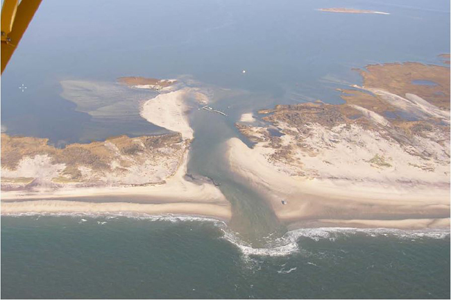
For orientation, the first photo taken in April 2005 (
pictured below)
shows the configuration of the Old Inlet area prior to the breach. In
the right-center of the picture, the Old Inlet dock and board walk
across the island are visible as is a small embayment that had
historically been used to tie up a ferry to bring people to the old
beach clubs that were in that area. The inlet formed in area of the
embayment and took out the entire boardwalk and part of the dock.
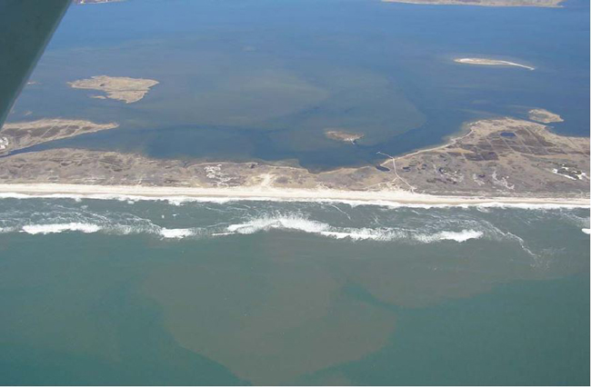
Aerial photo of the Old Inlet area taken by C. Flagg in April 2005.
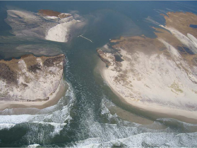
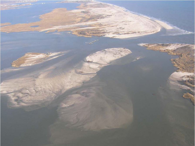
November 3, 2012
The two photos below were taken on November 3, 2012 near 12:30 GMT, five
days after the breach was formed. These are close up shots from the
south and southwest of the new inlet in which you can see the breach,
the Old Inlet dock that is no longer attached to the island, Pelican
Island in the background, and several new sand islands to the north and
west. All the photos were taken during flood tide. The new channel swept
in from the east and hugs the east side of the breach before most of
the flow turns west, south of the new sand islands.
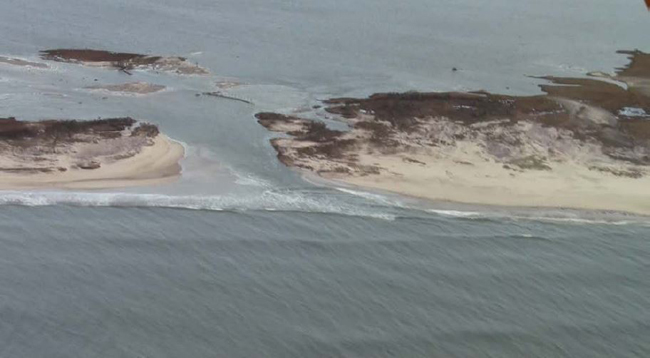
Aerial photo taken by C. Flagg and R. Giannotti on Nov. 3, 2012, from the south of the breach.
Aerial photo taken by C. Flagg and R. Giannotti on Nov. 3, 2012, from the southwest of the breach.
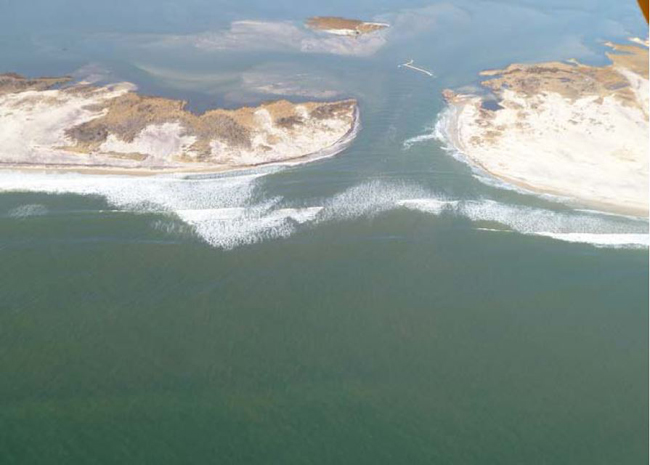
The last in this series of November 3, 2012 photos (
pictured below)
was taken from nearly directly overhead and clearly shows the
relationship between the breach channel and the familiar landmark of the
dock.
Aerial photo taken by C. Flagg and R. Giannotti on November 3, 2012, from the west of the breach.
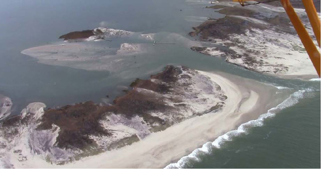
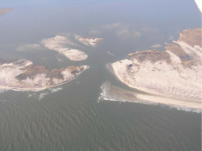
November 11, 2012
A series of aerial photos were taken a week later on November 11, 2012
around 1400 GMT, after a nor’easter passed through the area on November 7
and 8. There were substantial changes to both the main channel through
Fire Island and the sand islands in the bay. The initial cut through the
island had been fairly straight with the deepest part along the eastern
edge. As a result of natural adjustment but probably mostly as a result
of the nor’easter, the channel now has a decided offset to the west
between the ocean and bay ends of the channel. The offset appears
confined to the bay end of the channel while the ocean end does not seem
to have moved. Also there is less evidence of a single deep channel.
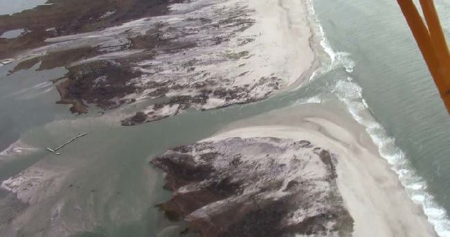
The most visible changes to the breach occurred in the sand islands that
had been formed by dune sands carried into the bay. Right after Sandy,
the sand islands were north of Fire Island and west of the inlet with
channels between the sand islands, Fire Island and Pelican Island. After
the nor-easter the connection with the bay, which had been to the west
just north of Fire Island, had completely switched directions and now
makes a connection to the old Old Inlet channel to the east. passing
under and through the dock as shown in the last photo below. As part of
this change was the build-up of what appears to be a fairly high sand
island that all but connects Fire Island to Pelican Island with a small
channel that passes under the Pelican Island dock. This change in flow
pattern now connects the inlet to the rest of Great South Bay through a
deeper channel with greater conveyance and that may extend the natural
lifetime of the inlet.
Aerial photo taken by C. Flagg and R. Giannotti on November 11, 2013.
November 18, 2012
A follow-up set of photos were taken on Sunday November 18th between
1700 and 1800 GMT. The November 18th photos show that the original
channel to the west, just north of Fire Island, had been re-established
although much of the sand bar to Pelican Island remained. The western
edge of the inlet near the ocean has eroded to the point that the offset
on November 11th had disappeared and the ebb-tidal delta clearly
exhibits east and west channels connecting the inlet to the ocean.
Aerial photo taken by R. Weissmann and R. Giannotti on November 18, 2013.
December 20, 2012
The next set of photos were taken a month later on December 20, 2012
between 1620 and 1700 GMT. Meteorologically, not much had happened
between the November 18 and December 20 photos, so there was a more
gradual evolution of the inlet as shown by a comparison between Figures 4
and 5. The most notable change was the disappearance of the sand island
south of Pelican Island, and the channel to the west, which had been
along the north shore of Fire Island, moved north closer to Pelican
Island. There also were changes to the inlet. The eastern side of the
inlet had migrated somewhat to the west. A bit of a bar had formed off
the east side shown by the breaking waves. And the low sand beach along
the western side had eroded away. The ebb shoal delta again visible in
the area of breaking waves and the east and west channels are also
evident.
Aerial photo taken by M. Ferrigno and R. Giannotti on December 20, 2012.
December 22, 2012 - January 6, 2013
In late December, there were a couple of storms that have again altered
the configuration of the inlet at both the ocean and bay ends. On
December 22 and 23. there was a sustained period of high westerly winds,
which caused a significant water level rise in Bellport Bay. This event
was followed a few days later by the passage of a nor’easter on
December 27, which caused a second period of high water level. The
combination of these storms have resulted in quite noticeable changes in
the configuration of the inlet and the back bay channels, as shown by
photos taken on January 6, 2013 around 2000 GMT.
Aerial photo taken by C. Flagg on January 6, 2013.
Along the ocean beach to the east of the inlet, an offshore bar formed
that moved onshore creating a series of ridges and runnels that
eventually connected to the ebb shoal. The ridge/runnel system extended
all along the beach to the east, and so was not particularly associated
with the inlet morphological dynamics. However, as the offshore bar
moved onto the beach, it cut off the east channel and forced all the
tidal flow to use the west channel, which caused it to enlarge and move
into the center of the inlet. As part of that process, it appears that
the ebb shoal delta has eroded away. At the same time, there was
significant deposition along the eastern edge of the inlet especially at
the northern end. Along the western edge of the inlet, there has been
considerable erosion with the shoreline moving up to the scrub line.
In the back bay area, a substantial sand island has formed causing the
formation of two channels to the west, one along the west side of
Pelican Island and second one just north of Fire Island.
The clarity of the water made the underwater shoaling to the north of
the inlet visible in a couple of the photos taken on January 6th and two
of these photos are shown in the two photos below. The sand island and
shoaling that extends off to the northwest of the inlet is at least 0.5
km long, while the shoals to the east of Pelican Island extend about 0.6
km from the inlet.
Aerial photo of the inlet from the northwest showing the extended sand
island and shoals to the west of the inlet. Photo taken by C. Flagg on Jan. 6, 2013.
Aerial photo of shoals to the northeast of the inlet. Photo taken by C. Flagg on January 6, 2013.
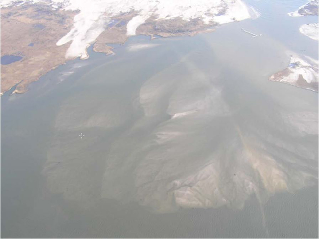
January 27-February 14, 2013
In the three week period between the photo above and below (1/6-1/27),
there has been a period of strong, but not storm, winds out of the west,
and in the last week the weather has been cold enough to freeze much of
eastern Great South Bay. The evolution of the inlet on the bay side was
not that extensive, but there were significant changes at the ocean
end, as pictured below. The offshore bar that was in the process of
moving shoreward on January 6th has completed that process, and the sand
associated with the ridge and runnel system along the eastern beach has
completely joined the beach. The sand, which was part of the offshore
bar that extended into the inlet, has attached itself to the eastern
edge of the inlet, while the sand at the northeast corner of the inlet
has disappeared. The ridge and runnel system that had been prominent
along the eastern beach has now formed along the western beach and
extended into the inlet forming a new ebb tidal delta, while the main
channel appears to have shifted slightly to the east as a result. And
there has been some additional erosion of the dune to the west.
The water was extremely clear during this latest over flight, which
permits a good view of the channels in the back bay area. These channels
show up quite prominently in the photo below as does the extensive area
of sand deposited in the Bay as a result of the inlet formation and
overwashes to the east. It now appears that there is one major channel
to the west close along Fire Island and two possibly shallower channels
to the northeast past Pelican Island. There had been snow during the
previous week so anything that shows up white is clearly above the high
tide line and that includes a number of portions of the new sand
islands.
Aerial photo taken by C. Flagg and D. Richards on January 27, 2013.
For the flight on January 27th, a video camera was fixed to the plane so
that it looked straight down providing photos with minimal spatial
distortion and from which one can make direct measurements. A mosaic of
video snapshots (courtesy of Mark Lang) taken of the inlet from a height
of 2000 feet is shown in the photo below. To get a scale, one can use
the remnants of the Old Inlet dock that measures about 52 meters from
the cross of the “T” on the northwest end to the last piece of the dock
to the southeast. If we use that as a scale, the narrowest part of the
inlet is about 85 meters across while the deepest part of the channel,
marked by the darkest colors, appears to be about 25 meters across. The
narrowest part of the channel to the west is also about 25 meters wide
while the channels to the northeast, although not that well defined,
vary from 10 to 20 meters wide. The flood delta shows several lobes and
channels, and it is clear that some sand deposits are now above water,
since there is white snow evident in many places that in the past were
under water. At the ocean end of the inlet, the light colored sand shows
quite a bit of shoaling to the west and even a small bar forming along
the eastern edge of the main channel.
It does not appear that there were significant alterations to the
inlet's inner portion from the January 31 wind event. Even the offshore
bar and runnel structure and offshore bar had changed but little. It was
a completely different story as a result of the February 8-9 blizzard
during which winds were initially out of the east before rotating to the
north and northwest. Water levels in the bay again reached fairly high
values of around 0.75 m above the long-term mean before retreating. This
time it appears that the setup against the island caused by the east
wind was responsible for the increased water level, overcoming the local
downwind setdown in the bay.
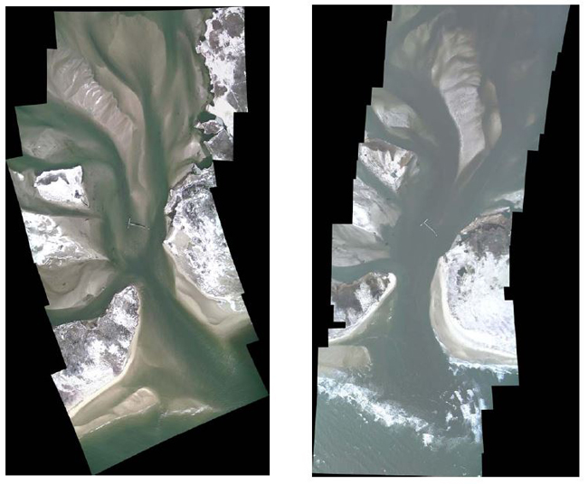
Photo mosaics of the inlet taken on January 27, 2013 (left) and February
2, 2013 (right). For scale, the remains of the Old Inlet dock is about
50 m long. Photos By C. Flagg and D. Richards, Compiled into mosaic by
Mark Lang.
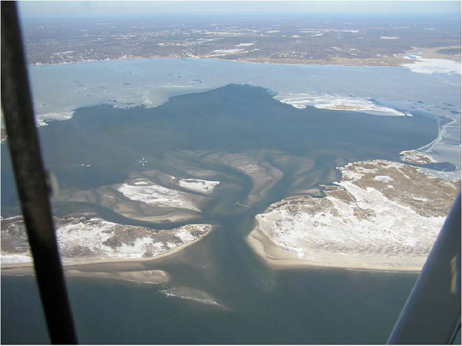
The photo below was taken on February 14, 2013, just a few days after a
winter blizzard. Over a period of three weeks in early February, the
eastern tip of the inlet’s western border showed about a 50 meter
retreat to the west (#1 on photo) and a large sandbar was building up on
the eastern shore (#2). At the same time, the main channels into
Bellport Bay passed close along Fire Island to west and south of the Old
Inlet dock to the east (#3), with some flow passing on either side of
Pelican Island. Although not shown in the photo below, the channels all
led to fan-shaped regions of shallow water often less than a foot deep
at low tide. A bathymetric survey of the breach area on February 22, a
week after the photo, indicated that there was a narrow channel about 7 m
deep just off the tip of the western shore where the currents were the
highest. At the northern and southern ends of the inlet, the water
depths were between 2 and 3 m as the currents spread out and slowed
down.
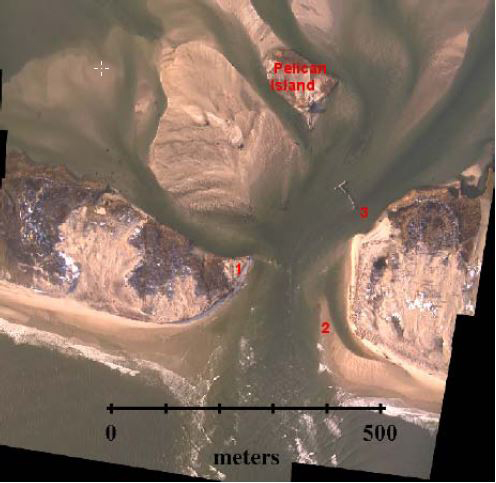
Photo mosaic from February 14 taken about an hour before sunset near low
tide. Photos By C. Flagg and D. Richards, Compiled into mosaic by Mark
Lang.
March 29-June 21, 2013
The photo mosaic below, from March 29, is quite similar to another one
taken of March 10, although the shoaling in the channel to the west just
north of Fire Island has increased. Also by the end of March the sand
bar that had moved into the inlet along the eastern side had increased
in size and consolidated. Evident in the March 29 and subsequent photos
is a runnel area between the eastern sand shoal and Fire Island to the
east. This runnel area has waxed and waned over the past three months
indicating that while the eastern sand shoal remains low enough to be
flooded at times, it has not been accessible to overwash for enough sand
to be deposited to fill the depression.
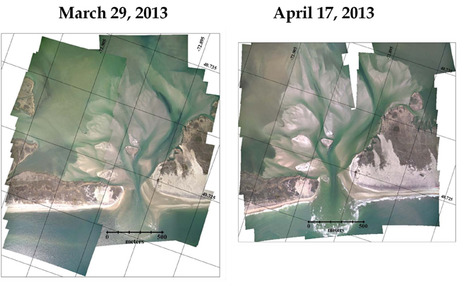
Photo mosaics from March 29 and April 17, 2013. Photos By C. Flagg and D. Richards, Compiled into mosaic by Mark Lang.
The major alterations to the inlet since the end of March involve the
development of a sand spit off the northwest corner of the inlet. On
March 29th (
as pictured above) there was just a small indication of a sandy area at the tip
of the island. The spit grew noticeably by April 17th (
as pictured above) and the shoal at
the entrance to the westward channel had grown as well essentially
cutting off the channel along the north side of the island.
By a month later on May 12th (
as pictured below) the spit had
grown to an area of about 200 meters by 100 meters and reduced the
western channel even further. At the end of May, the enlarged sand spit
remained and one can see that flow to the west had formed a new channel
north of the spit.
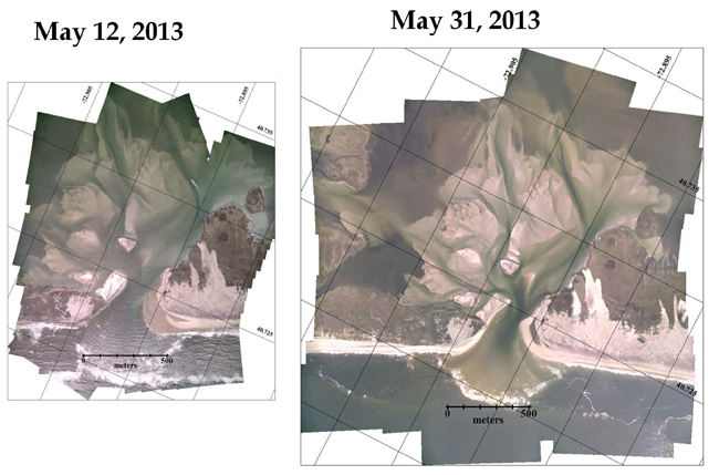
Photo mosaics from May 12 and May 31, 2013. Photos By C. Flagg and D. Richards, Compiled into mosaic by Mark Lang.
The evolution of the spit continued into June (
as pictured below)
when a small nor’easter on June 8th caused the erosion of the northern
end of the spit evident in the June 16 photo. Some erosion of the spit
had taken place on the west side, but most of it occurred in the inlet
area. The sand however was not washed out of the inlet but rather built
up an extensive shoal along the spit to the east. When we were out in
the inlet for another bathymetric survey on June 21st during an ebb
tide, the water was boiling over this shoal and it was quite shallow.
While the spit on the west was eroded as a result of the June storm, an
extensive shoal area formed along the east side of the inlet extending
from the northeastern corner of the inlet southward highlighted by the
breaking waves in that area in the photo below.
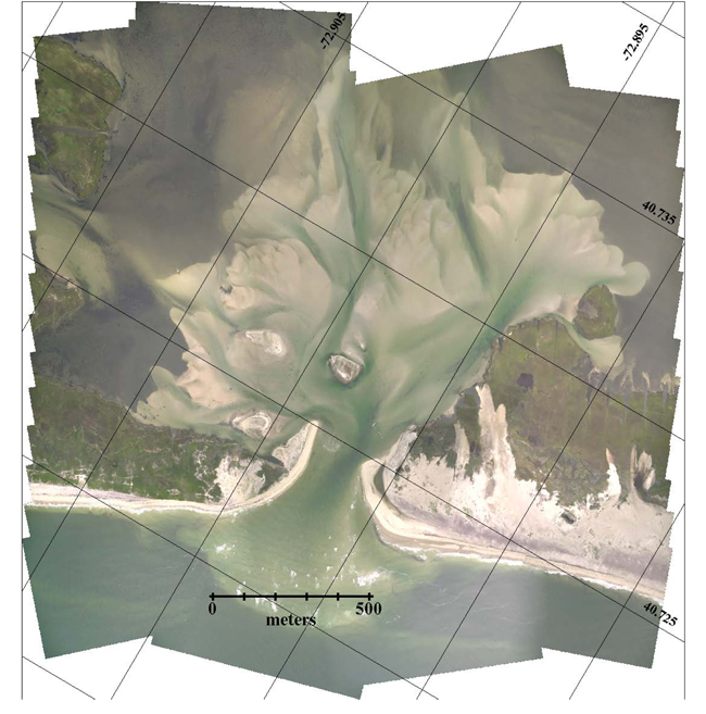
Photo Mosaic from June 16, 2013. Photos By C. Flagg and D. Richards, Compiled into mosaic by Mark Lang.
The changes in the back bay sand island, shoals and channels have not
been as dramatic as the changes in and along the inlet, but the
evolution of that area continues. In particular, the channels and shoals
off to the northeast keep changing. Since the storm at the end of
February when the gun club house on Pelican Island moved about 100
meters to the north, the area under the house’s previous location has
been part of a major channel to the north and east. The channel on the
west side of Pelican Island heading off to the north has also increased
in size. Early on in the development of the inlet, the main channel to
the east skirted along the north shore of Fire Island. That channel has
varied in size and location. Initially it was south of the Old Inlet
dock about which a sand shoal had formed. But later that shoal shifted
and spread out to the east, and there is now considerable flow through
the old dock. Much of the flow to the north and east is now funneled
into an area along the Fire Island shore near a little round island
known as Hospital Island. From there the flow splits, some of it spreads
out and flows off toward the Smith Point Channel and some flows to the
northwest, west of John Boyle Island.
Also, by the end of May the ocean beach to the west of the inlet had
built up considerably. This sand accretion extended along the west side
of the inlet and has remained.
On June 15th the remains of the
displaced gun club house were removed. When it moved off the island on
February 28th it sank in several feet of water and caused the flow in
that area to slow down and deposit sand around the house. So a shoal and
sand island formed around the house which is visible in all the photos
since then. However the photo taken on June 16th (
pictured above) - the day after the house was removed - already shows that the sand shoal around the house was beginning to erode away.
December 19, 2013 - January 21, 2014
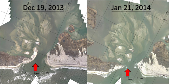
Photo Mosaic from December 19, 2013 and January 21, 2014. Photos By C. Flagg during overflight surveys of the Inlet, Compiled into mosaic by Mark Lang.
While a large and long west bank had been developing within Great South Bay’s New Inlet during the fall months, strong storms during January 2014 blew out this accumulation of sand, effectively widening the Inlet and possibly enhancing circulation.