New York, NY, March 18, 2014 - If mid-century projections of sea level rise prove true for New York City, the National Oceanic and Atmospheric Administration (NOAA) reports that four times as many people may be living in the 100-year floodplain than were previously estimated based only on observed changes.
The maps below show future flood zones for the area taking into account
sea level rise (
NOAA Climate.gov link) from both
ocean warming (
NOAA Climate.gov link) and
ice sheet melt (
NOAA Climate.gov link), and they factor in local conditions such as vertical land movement and regional climate variations. The maps, which were produced for a climate risk information report released by the
New York City Panel on Climate Change in June 2013 (
pdf), show areas projected to be inundated during a 100-year flood (left) and a 500-year flood (right).
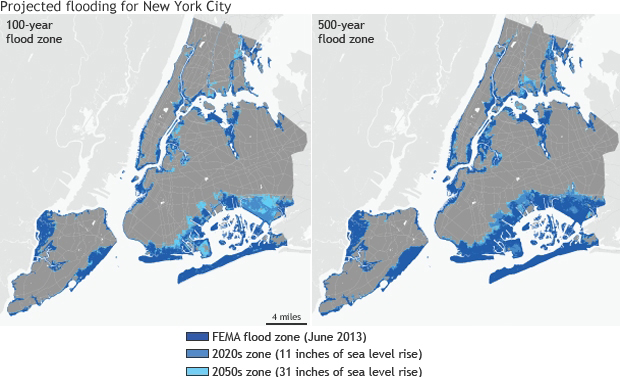
Projected future flood zones for New York City for the period 2020s and 2050s, developed by the New York Panel on Climate Change (NPCC) and published by NOAA on March 18, 2014. Since 2010, Stony Brook University (SBU) School of Marine and Atmospheric Sciences (SoMAS) oceanographer Malcolm Bowman has served on the NPCC and co-authored the report. NPCC, now a standing committee of the New York City Council, advises the Mayor and various departments (e.g., the Office of Long Term Planning and Sustainability, Parks Department and Transportation Department) on all climate change issues.
For over a decade, New York Sea Grant (NYSG) has funded studies of Bowman's as well as other investigators in the Stony Brook Storm Surge Research Group, for which Bowman is the lead.
Maps -Credit: NOAA Climate.gov, science and information for a climate-smart nation
Maps - Larger versions: 100-year flood map (
pdf) 500-year flood map (
pdf)
Each map shows how the Federal Emergency Management Agency (FEMA) flood zone (dark blue) could grow by the 2020s (medium blue) and 2050s (light blue) under an extreme sea level rise projection of 2.5 feet by 2050—an almost worst-case scenario that falls within the 90th percentile of projected estimates. By the 2020s, the middle range of projections is 4 to 8 inches, and the high estimate is 11 inches. By the 2050s, the middle range of projections is 11 to 24 inches, and the high estimate is 31 inches.
Areas in the 100-year flood zone have a 1 percent chance of being flooded annually and are particularly vulnerable to rising sea levels. The 100-year flood zone includes several communities that were hit hard by Sandy in late October 2012, including the Brooklyn-Queens Waterfront, the East and South Shores of Staten Island, South Queens, Southern Brooklyn, and Southern Manhattan. Structures in this zone are subject to special building codes and insurance and environmental regulations. Areas in the 500-year flood zone have a 0.2 percent chance of being flooded annually.
The report’s authors point out that the staggering extent and magnitude of coastal flooding during Sandy was likely influenced by sea level rise that has already occurred over the last century. (Sea level at the Battery Park tide gauge has risen 1.1 feet since 1900.) According to the
City of New York’s overview of Sandy’s impacts (
NYC.gov link), the floodplain boundaries on the FEMA flood maps in effect when Sandy hit indicated that 33 square miles of New York City might be inundated during a 100-year flood. By the end of the storm, 51 square miles flooded—17 percent of the city’s total land mass. This extent of flooding exceeded the 100-year floodplain boundaries by 53 percent citywide.
While the flood projection maps serve as a powerful tool for illustrating future trends and
informing long-term planning (
NOAA Climate.gov link), they are not intended to be used to judge site-specific risks, insurance rates, or property values. They also do not account for possible future changes in storm intensity and frequency that could affect the occurrences and height of storm surge. New York City is especially vulnerable to storm surge due to its dense population and location at the apex of the New York Bight—a slight indentation along the New York and New Jersey coastlines that can act to funnel and amplify storm surge in the Lower New York Harbor.
Maps by
NOAA Climate.gov based on data courtesy of FEMA (existing flood zones) and the New York City Panel on Climate Change (projected). Flood zones based on FEMA’s June 2013 preliminary work map data.
Related Resources
- New York City Panel on Climate Change: Climate Risk Information 2013 (pdf)
- The City of New York: A Stronger, More Resilient New York (click here)
Published June 11, 2013
- New York City Special Initiative for Planning and Recovery (click here)
- PlaNYC (click here)
More Info: New York Sea Grant
New York Sea Grant (NYSG), a cooperative program of Cornell University
and the State University of New York, is one of 33 university-based
programs under the National Sea Grant College Program (NSGCP) of the
National Oceanic and Atmospheric Administration (NOAA). The NSGCP
engages this network of the nation’s top universities in conducting
scientific research, education, training and extension projects designed
to foster science-based decisions about the use and conservation of our
aquatic resources. Through its statewide network of integrated
services, NYSG has been promoting coastal vitality, environmental
sustainability, and citizen awareness about the State’s marine and Great
Lakes resources since 1971.
For updates on Sea Grant activities:
www.nyseagrant.org has RSS,
Facebook,
Twitter, and
YouTube links. NYSG also offers a free e-list sign up via
www.nyseagrant.org/coastlines for
NY Coastlines, its flagship publication, which, in 2014, merges with the program's e-newsletter,
Currents.
NY Coastlines is published several times a year.