May 21-22 Public Listening Sessions to Help Create First-Ever Climatology Resource for Lake Ontario, Will Inform Channel Management Planning
Contacts:
Mary Austerman, New York Sea Grant Coastal Community Development Specialist, P: 315-312-3042, E: mp357@cornell.edu
John DeHollander, Oswego County Soil and Water Conservation District, P: 315-592-9663
Kara Lynn Dunn, Publicist, P: 315-465-7578, E: karalynn@gisco.net
Note: See individual project funding, comments from the Northeast Regional Climate Center, and details in the "More Info" sections below.
New York Sea Grant is leading a team that will create the first-ever
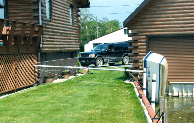
climatology resource for impact-producing Lake Ontario storms. A storm
in 2008 upturned this sailboat and pushed its mast into a neighboring
cottage at Sandy Pond; Photo courtesy of Ron and Emmy Fisher
Oswego, NY, May 1, 2015 - New York Sea Grant and the Oswego County Soil and Water Conservation District are asking the people who live, work and play along the Lake Ontario shoreline and on North Sandy Pond to share personal stories and photos of storm events to help local communities better assess risk, build storm readiness and resiliency, and reduce future storm damage and recovery expenses.
The lakeshore project will create the first-ever baseline climatology resource for impact-producing Lake Ontario storms. The North Sandy Pond project will inform channel management planning for the future and supports the lake storm information collection.
‘These two projects are focused on developing risk assessment and resiliency resources for the Great Lakes communities of New York. Existing science-based historical records and modern-day forecasting expertise from the Northeast Regional Climate Center at Cornell are being enhanced with public data,’ says Katherine Bunting-Howarth, Associate Director of New York Sea Grant and Assistant Director of Cornell Cooperative Extension, Ithaca, NY.
Residents, cottage and business owners, and visitors to the eastern Lake Ontario shore and North Sandy Pond areas are invited to meet with staff from New York Sea Grant and the Oswego County Soil and Conservation District to share their storm stories and photos at the Sandy Creek Town Hall, 1992 Harwood Drive, Sandy Creek, on May 21 and May 22 from 9am to 3pm. Appointments are not needed.
Those interested in sharing stories are asked to bring the dates; if possible, times; and locations for each storm they wish to report. Conversation will explore the types of damage and what factors, such as wind, ice, rain, snow, etc. might have influenced the severity of damage. For the North Sandy Pond project, the public is invited to share their experiences and historical knowledge about the pond, its barrier beach, and inlet.
If participants wish to bring storm damage photos, the photos will be scanned on-site to add to the project and historical records.
Information exhibits at the Sandy Creek Town Hall on May 21 and May 22 will include maps, aerial photos and other information on the Eastern Lake Ontario Dune and Wetlands Area and North Pond. The building is handicapped-accessible.
For more information, contact Mary Austerman, New York Sea Grant, at 315-312-3042, or John DeHollander, Oswego County Soil and Water Conservation District, 315-592-9663.
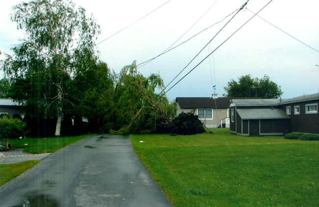
Learning more about Lake Ontario storms may help property owners better anticipate and prepare the risk of storm damage. Photo courtesy of Ron and Emmy Fisher
More Info: Lake Ontario Climatology Project
With funding from the National Oceanic and Atmospheric Administration Coastal Storms Program, New York Sea Grant is working with Cornell University and the Northeast Regional Climate Center to develop the first-ever baseline climatology resource for impact-producing Lake Ontario storms in the 17-mile stretch of Eastern Lake Ontario Dunes and Wetlands system from Deer Creek Marsh in Oswego County to Black Pond in Jefferson County, and the Sodus Bay area of Wayne County.
‘This project is designed to develop a tool that will identify weather patterns similar to those in the past that caused specific types of damage. We will investigate how storm occurrence has changed has since 1950, and, in time, we hope to say how frequently certain types of storms occur on Lake Ontario. The first step is this historical baseline,’ says Northeast Regional Climate Center Director Art DeGaetano.
‘Public reports of damage to natural and manmade environments from past storms will be matched with historical meteorological data to develop this first-ever resource for the Great Lakes region in New York. Our goal is to educate landowners, public and private property managers, and municipalities about Lake Ontario’s unique climatology and to encourage measures that will reduce impact when a storm similar to one in the past is expected,’ says New York Sea Grant Coastal Community Development Specialist Mary Austerman.
‘The new climatology resource can assist communities in preparedness planning and be used to determine the risk of future impact by storms occurring along the eastern shore and Sodus Bay areas,’ Austerman adds.
Oswego County District 1 Legislator Margaret Kastler, The Oswego County Environmental Management Council, Eastern Lake Ontario Dune Coalition, and The Ontario Dune Coalition have provided guidance to these projects.
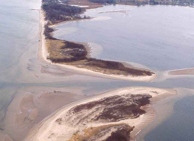
The public is invited to share experiences and historical knowledge
about North Sandy Pond, its barrier beach and inlet to help inform
development of future channel management planning. Listening sessions
are set for May 21-22 at the Sandy Creek Town Hall. Photo: Geoff Steadman
More Info: North Sandy Pond Project
In January 2015, the New York State Department of Environmental Conservation and New York Sea Grant announced a Great Lakes Basin Small Grant award of $25,000 to the Oswego County Soil and Water Conservation District to identify and assess shoreline management opportunities to inform future management planning and support ecosystem stability in the North Sandy Pond area. The New York Great Lakes Basin Small Grants Program is a project of the state Environmental Protection Fund and Environmental Conservation Program.
The North Sandy Pond channel provides boaters and anglers access to Lake Ontario, and plays an important role in controlling flooding, and maintaining water quality and natural resources such as wetlands. The goal of the North Sandy Pond project is to better understand the dynamic nature of the inlet and how it affects both barrier beaches and sand movement in Lake Ontario and North Sandy Pond.
‘Understanding the historical and recent impacts to North Sandy Pond caused by natural occurrences, such as extreme precipitation and runoff events, strong wind events, and severe drought conditions, as well as major human interventions that may have influenced the stability of the barrier and beach dune system, will help us be better prepared for coping with future changes,’ says project manager John DeHollander, District Manager of the Oswego County Soil and Water Conservation District, Fulton, NY.
According to environmental scientist Thomas Hart, Voorheesville, NY, there have been no fewer than five different North Sandy Pond inlet locations in the past 120 years, and the odds of a future change in inlet configuration or location are increasing.
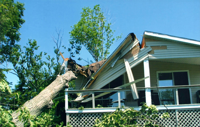
An example of storm damage along Lake Ontario's shoreline. Photo courtesy of Ron and Emmy Fisher
More Info: New York Sea Grant
New York Sea Grant (NYSG), a cooperative program of Cornell University
and the State University of New York, is one of 33 university-based
programs under the National Sea Grant College Program (NSGCP) of the
National Oceanic and Atmospheric Administration (NOAA). The NSGCP
engages this network of the nation’s top universities in conducting
scientific research, education, training and extension projects designed
to foster science-based decisions about the use and conservation of our
aquatic resources. Through its statewide network of integrated
services, NYSG has been promoting coastal vitality, environmental
sustainability, and citizen awareness about the State’s marine and Great
Lakes resources since 1971.
For updates on Sea Grant activities: www.nyseagrant.org has RSS, Facebook, Twitter, and YouTube links. NYSG also offers a free e-list sign up via www.nyseagrant.org/coastlines for its flagship publication, NY Coastlines/Currents, which is published several times a year.