New York, NY, May 30, 2013 - History teaches that hurricane awareness and preparation are common threads that can reduce the impact of hurricane disasters. Families, individuals, and businesses who know their vulnerability and what actions to take can reduce the effects of a hurricane disaster by taking action to prepare.
In support of this call to prepare, the Federal Emergency Management Agency (FEMA) and the National Oceanic Atmospheric Administration (NOAA) have partnered again to promote 2013 National Hurricane Preparedness Week, and are calling upon Americans in areas of the country vulnerable to hurricanes and severe weather to Be a Force of Nature.
New York Sea Grant (NYSG) is proud to join and promote the 2013 National Hurricane Preparedness Week and to Be a Force of Nature to help spread the word and make its employees and members of the community better prepared. NYSG provides the science behind storms like Superstorm Sandy last fall via its Hurricane Education resource site, www.nyseagrant.org/hurricane. There, you'll find a news archive as well as links to topical agencies and organizations and information on how to best be prepared in the event of a hurricane.
The Benefits of Social Media in Times of Sandy and Other Storms
Recent studies show that many people use social media in the event of a disaster to let relatives and friends know they are safe. This is an important trend because people are most likely to take preparedness steps if they observe the preparations taken by others.
For example, before, during and after Sandy's landfall, NYSG's Web Content Manager Paul C. Focazio worked with several researchers who corrected inaccuracies being reported about the Superstorm's track on the East Coast. When these researchers made the rounds in media discussions, including The New York Times, The Wall Street Journal, NBC News, ABC News, AP and Newsday, Focazio was updating content on NYSG's Hurricane Education resource site to keep visitors well informed.
The researchers - Drs. Malcolm Bowman and Brian Colle at Stony Brook University (SBU) School of Marine and Atmospheric Sciences (SoMAS) - are considered leading scientific experts on storm surge, flooding and climate change in the Metro New York region.
For the last decade, NYSG has provided principal funding to Bowman, Colle and the rest of SBU's Storm Surge Research Group to work on storm surge science, coastal defense systems and policy issues related to regional protection of New York City and Long Island. The Group was initially formed to develop coastal early warning system for emergency response against flooding in Metropolitan New York.
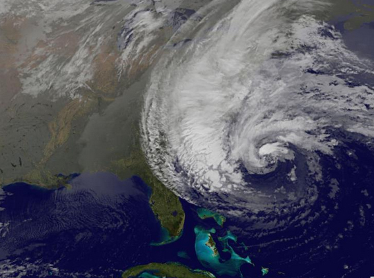
NOAA satellite image of Sandy on October 28, 2012.
In addition to supporting the SBU's Storm Surge Research Group's research, NYSG has played a role in providing sound information to managers and stakeholders in a timely way since Superstorm Sandy - from rapid-response and long-term research to aiding federal, state and local officials on assessing the "Old Inlet" breach in Fire Island. For more, see NYSG's related news item, "New York Sea Grant Responds to Superstorm Sandy."
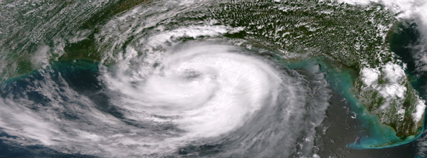
At 1:35pm CDT on August 28, 2012, the NOAA/NASA Suomi NPP satellite flew over Isaac, capturing this image of the storm with the true color capability of the VIIRS sensor. Image: NOAA/NASA. Data courtesy of the NOAA/NASA Suomi NPP satellite.
For more, see New York Sea Grant's related news item, "Hurricane Isaac: NOAA Updates, Reflections on Irene and Katrina."
As NOAA and FEMA have touted during the annual National Hurricane Preparedness Week, social media provides the perfect platform to model preparedness actions for others. For this reason, they (and New York Sea Grant) are asking you to pledge and take the following steps:
-
Know your risk: The first step to Be a Force of Nature is to understand how hurricanes can affect where you live and work, and how the weather could impact you and your family. When you understand your risk, you are more apt to know how to prepare. Check the weather forecast regularly and sign up for local alerts from emergency management officials and obtain a NOAA Weather Radio.
-
Take action: Pledge to develop an emergency plan based on your local hurricane, severe storms and flooding hazards and practice how and where you will evacuate if instructed by your emergency management officials. Post your plan in your home where visitors can see it. Learn how to strengthen your home and business against hurricanes. Download FEMA’s mobile app so you can access important safety tips on what to do before, during and after a hurricane. Understand the National Hurricane Center warning and alerts.
-
Be an Example: Once you have taken action and pledged, share your story with your family and friends. Create a YouTube video, post your story on Facebook, comment on a blog, or send a tweet.
Also, familiarize yourself and your family with severe weather terminology so you can be a force of nature this season:
-
A hurricane warning means *one is expected* in your area. Follow evacuation orders from local officials if given
-
A hurricane watch means *one is possible* in your area. Know your evacuation route & listen to local officials.
2013: A Stormy Outlook for Hurricane Season
Hurricane season in the Atlantic begins June 1st and ends November 30th. The Eastern Pacific hurricane season begins May 15th and also ends November 30th.
As announced on May 23rd, NOAA is predicting an active 2013 Atlantic hurricane season, continuing an era of high activity for Atlantic hurricanes.
In its 2013 Atlantic hurricane season outlook, NOAA’s Climate Prediction Center is forecasting an "active or extremely active season" this year. And, before the season officially begins, the first named Hurricane of the season, Barbara, has already made
her presence known. As reported by NOAA National Weather Service (NWS) National Hurricane Center
(NHC) yesterday (May 29, 2013), "Barbara was over the eastern North Pacific Ocean - nearing the
coast of southern Mexico with 75 mph maximum sustained winds, and is
expected to cross the coast in the hurricane warning area during the
next several hours." Overnight, however, Barbara had weakened to a tropical depression and was still crossing the Isthmus of Tehuantepec this morning (May 30, 2013). NOAA NWS reported that the center should emerge over the extreme southwestern Gulf of Mexico later today. Barbara is forecast to weaken to a remnant low.
Because the intensity and track Barbara and other storms change rather quickly, NOAA NWS provides the latest forecasts,
warnings, graphics and expected impacts via the NHC website.
For the six-month Atlantic hurricane season, which begins June 1, NOAA’s Atlantic Hurricane Season Outlook says there is a 70 percent likelihood of 13 to 20 named storms (winds of 39 mph or higher), of which 7 to 11 could become hurricanes (winds of 74 mph or higher), including 3 to 6 major hurricanes (Category 3, 4 or 5; winds of 111 mph or higher). These ranges are well above the seasonal average of 12 named storms, 6 hurricanes and 3 major hurricanes. For more, see NOAA's related press release.
Remember: Atlantic hurricane season starts June 1, so get ready! For late-breaking hurricane watches and warnings this season, bookmark www.hurricanes.gov and follow the NOAA NWS National Hurricane Center on Twitter at @NHC_Atlantic and NOAA's U.S. National Weather Service at @usNWSgov.
NOAA has also issued the seasonal outlooks for 2013 Central Pacific hurricane season and the 2013 Eastern Pacific hurricane season. Click the links to find out more and follow NOAA's National Hurricane Center Twitter feed for the Pacific at @NHC_Pacific for late-breaking storm updates.
On YouTube: NOAA National Weather Service National Hurricane Center's Hurricane Preparedness PSAs
Overview of a Hurricane
NHC Hurricane Specialist Unit Branch Chief James Franklin provides an overview of the hurricane hazards and the importance of not using the seasonal outlook to prepare for the season.
Storm Surge
NHC Warning Coordination Meteorologist Daniel Brown describes the dangers of storm surge, the number one killer in a tropical cyclone.
Wind
NHC Hurricane Specialist Eric Blake discusses the winds associated with tropical cyclones, and the importance of having a NOAA Weather Radio.
Inland Flooding
NHC Hurricane Specialist John Cangialosi discusses the deadly danger of inland flooding caused by tropical cyclones.
The Forecast Process
NHC Senior Hurricane Specialist Dr. Michael Brennan describes the collaborative process in forecasting the track and intensity of a tropical cyclone.
Get a Plan!
FEMA Administrator Craig Fugate explains the importance of having a hurricane plan.
Taking Action
NHC Senior Hurricane Specialist Stacy Stewart discusses the life-saving action to take before, during and after the storm.
More Info:
New York Sea Grant (NYSG), a cooperative program of Cornell University
and the State University of New York, is one of 33 university-based
programs under the National Sea Grant College Program (NSGCP) of the
National Oceanic and Atmospheric Administration (NOAA). The NSGCP
engages this network of the nation’s top universities in conducting
scientific research, education, training and extension projects designed
to foster science-based decisions about the use and conservation of our
aquatic resources. Through its statewide network of integrated
services, NYSG has been promoting coastal vitality, environmental
sustainability, and citizen awareness about the State’s marine and Great
Lakes resources since 1971.
For updates on Sea Grant activities: www.nyseagrant.org has RSS, Facebook, Twitter, and YouTube links. NYSG also offers a free e-list sign up via www.nyseagrant.org/coastlines for NY Coastlines, its flagship publication, and Currents, its e-newsletter supplement, each distributed 3-4 times a year.