Disclaimer: The opinions expressed in the articles described are those of the individual researchers quoted and not of New York Sea Grant.
Friday, November 2, 2012, Stony Brook and New York, NY - It was only a matter of a few weeks ago when media outlets including The New York Times (click here) and CBS News (click here) furthered the conversation about storm surge concerns. As seen in those and other reports, it's a prime topic of concern being studied by Stony Brook University (SBU) School of Marine and Atmospheric Sciences' (SoMAS) Storm Surge Research Group.
For the last decade, New York Sea Grant has provided principal funding to
this Group to work on storm surge science, coastal defense systems and
policy issues related to regional protection of New York City and Long
Island. In their most recently NYSG-funded project, which began this past February, the Group is working towards creating a more accurate ensemble-based and wave setup-enabled storm surge model prediction system that could easily be adopted by the National Oceanic and Atmospheric Administration (NOAA) National Weather Service as well as regional emergency managers for regular and accurate predictions over the Northeast seaboard with a focus on Metropolitan New York and Long Island.
Why might such a comprehensive system be important to the region? Cue our current response to the damage sustained and lives lost from superstorm Sandy. SBU oceanography professor and storm surge expert Malcolm Bowman and other Research Group investigators, including SBU SoMAS
researcher Brian Colle, tracked what many were calling "The Perfect Storm" extensively, providing their
results on Sandy via E-mail, the Research Group's Web site, and New York Sea Grant's Twitter and Facebook feeds.
Bowman - also leader of the Research Group - reminds that much of New York's metropolitan area (about 100 square miles) lies just a few feet above sea level and millions of people live close to New York City’s 520 miles of coastline. Therefore, he and the other members of the Research Group warn that New York Metropolitan region is vulnerable to coastal flooding from hurricanes and nor'easters as well as related large-scale damage to city infrastructure, such as hospitals, airports, railroad and subway station entrances, highways, water treatment outfalls and combined sewer outfalls.
"There are 2 to 3 million people at risk," Bowman told CBS News in early October, adding that it was time to take bold action. "This could be an ideal location to build a barrier." Bowman thinks this could be the solution - gates in New York's Harbor. As seen in the segment below, Bowman illustrates an animation that lays out his vision - three multi-billion dollar barriers he says could save the region from disaster.
In addition to providing up-to-the-minute details about the storm's track, the Research Group's reports before, during and after Sandy's arrival served to correct several data misinterpretations. First, Colle said in his Monday, October 29 @ 3 pm report that media and other sources may be mis-reading the storm surge guidance from the National Oceanic and Atmospheric Administration (NOAA) and others. "The 10+ ft is relative to mean low low water (MLLW). One has to subtract the tide to get the surge, which is more like 5-8 ft. Still ugly, but not as catastrophic as some are saying right now on TV."
Second, later that night, around 10 pm, the New York broadcast media were incorrectly reporting a coastal flooding situation in lower Manhattan. "This ended up being a false report that the New York Stock Exchange's trading floor was under three feet of water," says Colle. "Although, there was confirmed flooding at the Ground Zero site, Hoboken train station (Path trains), and Midtown and Battery Tunnels."
For more of the details the Research Group provided leading up to and during the storm ...
- Read the running blog provided by Colle and Bowman below. This blog includes images during and after the storm, from as far east as Orient Point on Long Island's North Fork to Port Jefferson (located further west on the North Shore of Suffolk County, right next door to Stony Brook University) and Lindenhurst (even further west on Suffolk County's South Shore in the Town of Babylon).
- The Atlantic featured a comprehensive collection of 54 storm photos on October 30, 2012 - from sources including AP, Reuters and Getty and
featuring locations throughout Long Island, New York City, New
Jersey, and in other mid-Atlantic and Northeast states. click here (pdf)
-
Check out more discussions by Bowman and others related to storm surge issues in and around New York City via the links in the "Related Info" box on this page.
-
NYSG-funded projects on the topic can be found via a search of NYSG's Research Database - You can best find them easiest by searching by Institution (Stony Brook University), Investigator (Dr. Malcolm J. Bowman).
-
Click over to New York Sea Grant's extensive Hurricane Education Site, which has numerous site links, including ones related to volunteer efforts and resources for teachers, students and kids.
Also, here are some links for the Stony Brook Storm Surge Research Groups as well as other partners and related resources:
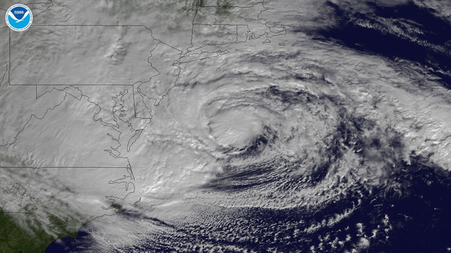
A NOAA GOES-13 satellite-produced image of Sandy descending on the U.S. Northeast on Monday, October 29. This image shows the storm as it is centered off of Maryland and Virginia, is heading in a northwestern direction towards the Delaware and southern New Jersey coasts.
Stony Brook University Storm Surge Research Group - Reports on Sandy, Saturday, October 27 - Tuesday, October 30
SATURDAY, OCT 27 @ 6:33 PM
Highest storm tide (total water level) predicted for The Battery is 3.3 m above MLLW (Mean Lower Low Water) at 7 pm Monday (a surge of 2.2 m above normal).
Highest storm tide (total water level) predicted for Bridgeport (and hence Port Jefferson and Stony Brook) is 3.5 m above MLLW at 12 noon Monday (a surge of 1.5 m above normal).
Other predictions, including the south shore of LI are given at stormy.msrc.sunysb.edu.
Hurricane SANDY Public Advisory, NUMBER 22 (Some Highlights)
National Weather Service National Hurricane Center Miami FL 500 pm EDT Sat Oct 27 2012 High wind watches and warnings are in effect for the mid-Atlantic states and southern New England...significant storm surge is also expected...
Hazards Affecting Land
Gale force winds are expected to arrive along portions of the mid-Atlantic coast by late Sunday or Sunday night and reach Long Island and southern New England by Monday morning. Winds to near hurricane force could reach the mid-Atlantic States...including Long island...by late Monday.
Storm surge...the combination of a dangerous storm surge and the tide will cause normally dry areas near the coast to be flooded by rising waters. The water could reach the following depths above ground if the peak surge occurs at the time of high tide...
Long Island Sound...Raritan Bay...and Delaware Bay...4 to 8 ft.
Rainfall amounts of 1 to 3 inches with isolated maximum amounts of 5 inches are possible across parts of southern New York into New England.
Surf...dangerous surf conditions will continue from Florida through the Carolinas for the next couple of days and spread into the mid-Atlantic and northeastern states by Sunday.
SATURDAY, OCT 27 @ 9:13 PM
Hurricane Sandy is now transitioning to an extratropical (nor-easter) cyclone. As a result, the National Hurricane Center will not be issuing any Hurricane/tropical storm warnings for this storm, since for a nor'easter type storm, the National Weather Service only issues high wind warnings for winds > 50 kts and coastal flood warnings. This is causing some confusion, and I fear the public, the university, and NYC are not taking this storm as seriously as they did for Irene last year.
The fact is that this storm will likely be worse than Irene for Long Island, both in terms of wind (45-60 mph, gusts to 80 mph-- we only had wind gusts to 60 mph in Irene), and storm surge (the predicted surge is now expected to be greater than the 1992 nor'easter that flooded NYC subways, etc...). Unfortunately, Mayor Bloomberg is not ordering evacuations for NYC, which I feel is a major mistake given the flooding will be worse than Irene.
Many in the media are focusing too much on the expected landfall location of the center of the storm over New Jersey. The fact is for nor'easters the strongest winds are often extend hundreds of miles from the center, which will be the case for this storm. Therefore, the expected landfall in central New Jersey is the worst case scenario for us, especially for wind and surge.
Hopefully, everyone is preparing for this storm like they did for Irene, and Stony Brook Univ (and the Governor) are not going to make everyone report to work Monday simply because the storm is no longer a labelled as a hurricane (or does not have a name). If there are lives lost in this event across the Northeast U.S., this will likely result in changes, such that nor'easters are named storms too (or hurricanes to nor'easter transitions keep their names), since a named storm is what seems to get the public and media's attention.
SUNDAY, OCT 28 @ 1:23 PM
This could be a historic flooding event for the north shore as well, which includes Port Jefferson (eg., lower Main St), Setauket, and Stony Brook harbor area. Current storm surge predictions are 6-12ft in these areas, which combined with spring high tides, may cause major problems. If you live (or know someone that lives) < 4 m above mean sea level in these areas, please protect property and seriously consider evacuating.
SUNDAY, OCT 28 @ 8:39 PM
Bulletin (Some Highlights)
Hurricane Sandy Intermediate Advisory Number 26a
NWS National Hurricane Center Miami Fl 800 Pm EDT Sun Oct 28 2012
...Sandy expected to bring life-threatening storm surge flooding to the mid-Atlantic coast...including Long Island Sound and New York Harbor...
In Addition...Hurricane-Force Winds Are Expected Along Portions Of The Coast ...New Jersey...The New York City Area...Long Island...Connecticut...And Rhode Island.
Hazards Affecting Land
Gale Force Winds Are Expected To Arrive Along Portions Of The Mid-Atlantic Coast Later Today...And Reach Long Island And Southern New England By Monday Morning. Winds Of Hurricane Force Could Reach The Mid-Atlantic States...Including Long Island...By Late Monday.
Storm Surge...The Combination Of An Extremely Dangerous Storm Surge And The Tide Will Cause Normally Dry Areas Near The Coast To Be Flooded By Rising Waters. The Water Could Reach The Following Depths Above Ground If The Peak Surge Occurs At The Time Of High Tide... Long Island Sound...Raritan Bay...And New York Harbor...6 To 11 ft.
MONDAY, OCT 29 @ 3 PM
Sandy has increased her forward motion and will actually make landfall on the southern New Jersey coast in a couple hours. This is 4-5 hours faster than even the predictions from this AM. This is good news in some respects, since it means that for NYC and for many south shore communities, the next high tide (9-10pm) will be the biggest surge (water levels), and then the water should start to recede.
The winds this evening will also switch from more of the SE or southerly direction, which means the surge should decrease everywhere. In fact, I think the worst is behind us on Long Island's North Shore. I know Port Jeff lower Main St had water around Danfords for high tide today around noon, but this next North Shore high tide later tonight should not be as bad with a more SE or S wind blowing water out of the harbor.
By the way, NY's Governor (and others in media) are saying that there will be a 10+ ft surge at the Battery. Unfortunately, they may be mis-reading the storm surge guidance from the National Oceanic and Atmospheric Administration (NOAA) and others. The "10+ ft" is relative to mean low low water (MLLW). One has to subtract the tide to get the surge, which is more like 5-8 ft. Still ugly... but not as catastrophic as some are saying right now on TV.
In terms of wind, we are currently sustained at 35-kts, with gusts to 55kts (60 mph). Believe it or not, it is blowing 100 mph just 1,000-2,000 ft above our heads, but there is a low-level stable layer
preventing the mixing down of some of this higher momentum down to the surface. This is saving us right now from wide spread power outages. You may notice that the wind comes in spurts -- lull for a few minutes and then a big gust. The gusts are associated with the large over-turning eddies in the lower atmosphere, but this stable layer is preventing efficient mixing down of the more damaging winds. However, later this afternoon and this evening, there is a chance this stable layer will weaken and we will see some gusts to at least 70 mph, so don't let your guard down.
If you live (or know someone that lives) < 4 m above mean sea level in these areas, please protect property and seriously consider evacuating.
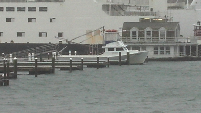
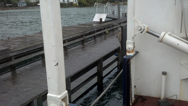
Captions for three photos above: Stony Brook University (SBU) School of Marine Atmospheric Sciences' (SoMAS) RV/Paumanok (in the pictures above) and R/VSeawolf (located on the docks of Long Island's North Shore town of Port Jefferson) weathered the storm well, so says SBU's Mark Wiggins. "Because the storm center was well south of us and then went well inland, we never saw any wind with a westerly component. The Paumanok and Seawolf are not sheltered very well from westerly winds. But since we are in the lee [sheltered side] of Bell Terre [an incorporated village that juts out into Port Jefferson harbor to the west and Long Island Sound to the east] we are very sheltered from any easterly winds."
Wiggins and fellow SoMAS staffer David Bowman were aboard Seawolf for the high tides around noon and midnight on October 29th. "The concern was that in very high water the boat could pull the lines off the tops of the pilings setting the boat free, or override the pilings damaging the dock and possibly pulling a hole below the water line," said Wiggins. "We came close to having to depart the dock on the midnight tide. At the noon tide, the water was about 4" above the top of the pier decking. On the midnight tide the water was about two feet above the decking. This left only about a foot of the pilings above water. But since there was no waves and little wind we were able to stay at the dock." Photos by David Bowman, SoMAS.
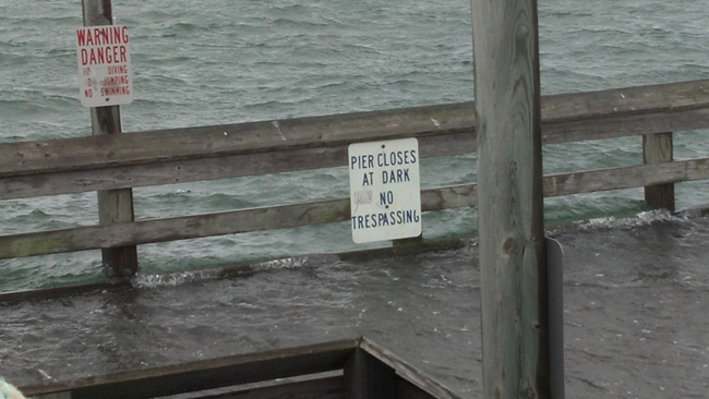
In Stony Brook harbor, just east of Port Jefferson on Long Island's North Shore, Larry Swanson, Associate Dean at SoMAS, said that after running data for the day [Monday, October 29, 2012] against the storm high water mark, "The height reached at the yacht club was 12.4 ft above MLW (Mean Low Water). This is 0.4 ft below that of the Dec 11, 1992 [nor'easter] storm. The reasons that it wasn't higher is probably because the peak surge actually occurred two hours before high water and the predicted high water was lower than that in 1992 (about 0.8 ft). The midnight predicted high tide was the lower of the two highs on Monday."
MONDAY, OCT 29 @ 9:30 PM
The hurricane force wind gusts sure materialized this evening as we got more vertical mixing.. peak wind so far of 94 mph at Eaton's Neck this evening, and 70-80 mph at many other locations. More importantly, all this ESE and SE wind has put an incredible amount of water into Long Island Sound this evening (more than forecast), and I am getting reports now that the water levels around Setauket, etc... may already be just as bad as the high tide at noon today. This means this next high tide (midnight) could be 2-3 ft higher than current water levels. If the wind can rotate to more S before then, that will help, but please do not take any chances if you are in those areas.
Almost a 3 m surge at the battery so far, which is record perhaps going back perhaps to the 1892 hurricane. Water everywhere there (Battery, lower East side, etc...), and rumors that Coney Island is cutoff now. Winds should slowly start weakening after midnight as the gusts decrease to less than 60 mph.
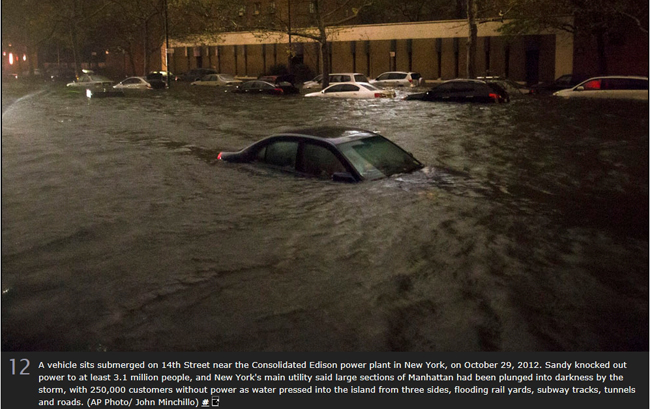
Photo courtesy of AP / Reprinted by The Atlantic.
Click here (pdf) for The Atlantic's full collection of 54 storm photos published on October 30, 2012 - from sources including AP, Reuters and Getty and featuring locations throughout Long Island, New York City, New
Jersey, and in other mid-Atlantic and Northeast states.
MONDAY, Oct 29 @ 9:51 PM
Just got a new report below...
09:27 PM COASTAL FLOOD MANHATTAN 40.78N 73.97W 10/29/2012
NEW YORK NY BROADCAST MEDIA
NEW YORK STOCK EXCHANGE TRADING FLOOR UNDER 3 FEET OF WATER.
MONDAY, October 29 @ 10:30 PM
This ended up being a false report with stock exchange, although there is confirmed flooding at ground zero site, Hoboken train station (PATH trains), and Midtown and Battery tunnels.
TUESDAY, OCT 30
Service was interrupted at approximately 6pm Monday night as Sandy caused a campus-wide power outage [at all Stony Brook University campuses]. Our surge model, and the weather models they are based on, take approximately three days to fully reset, "spin up", and settle back down.
In the coming days and weeks we will be re-analyzing our surge results and working with our colleagues at NOAA/NWS and Stevens Institute to identify areas where our predictions worked well, and where they did not. Due to the rarity of these extreme surge events it is only through this post-hoc re-analysis that we can provide a clear test for the system under realistic storm conditions. Together with archived weather data from Hurricanes Gloria, Floyd, and Irene we will use Sandy as a case study to run, and re-run, our models in order to improve our understanding of the underlying science, improve the predictive accuracy, and extend the period of advanced warning.
More images of flooding events resulting from the storm ...
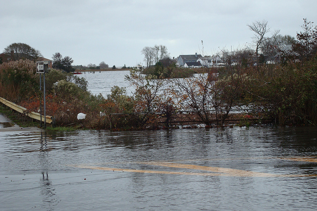
Post-Sandy photos taken taken at the Cross Sound Ferry in Orient, which is on the tip of eastern Long Island's North Fork, and in Lindenhurst, located in the south western portion of Long Island's Suffolk County. All courtesy of ICE-Cornell Cooperative Extension and NYSG.
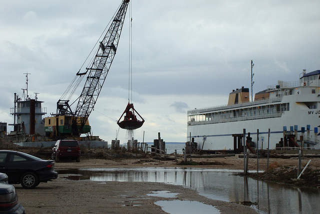
Dredging at the Cross Sound Ferry Station in Orient Point, Long Island, NY (October 31, 2012)
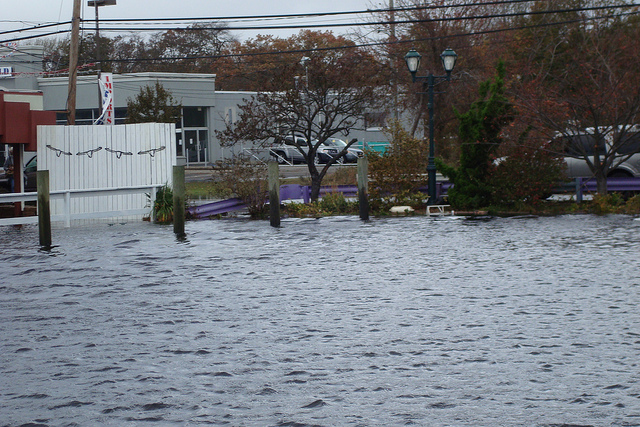
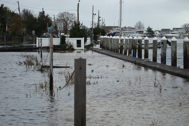
Marina on E Shore Road, Lindenhurst, Long Island, NY - looking back towards interception of Neguntatogue Creek.
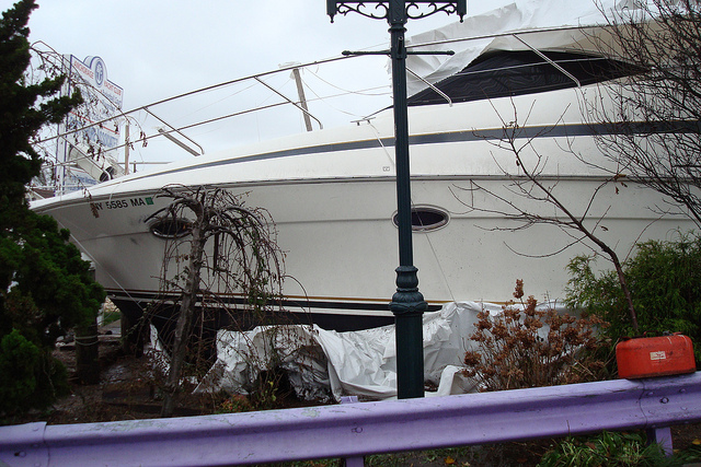
This boat, carried onto shore adjacent to Montuak Hwy from the marina in Lindenhurst, sustained damages.
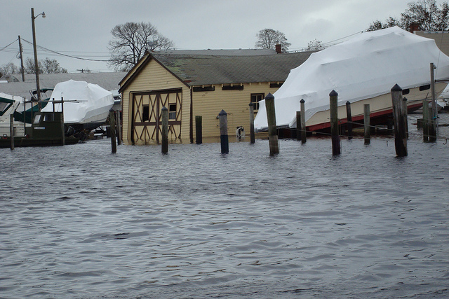
Sandy left behind considerable flooding at Lindenhurst's marina, as seen in the pictures directly above and below.
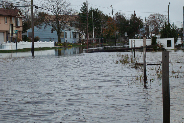
Houses on E Shore Rd adjacent to Neguntataogue Creek in Lindenhurst were flooded as a result of Sandy.
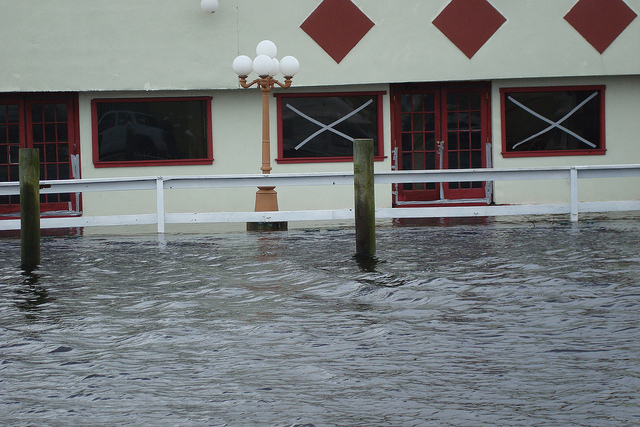
Cattleman Steakhouse in Lindenhurst, adjacent to the Neguntataogue Creek, was also one of the locations that sustained flood damage.
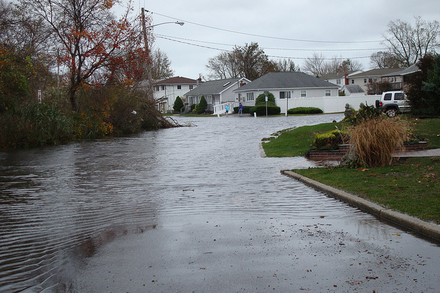
Homes on West Lake Dr. in Lindenhurst saw overflow from nearby Santapoque Creek.
Flooding, as seen facing west on Montauk Hwy at the junction with Santapoque Creek, Lindenhurst.